Start at the top for an easy introduction. Go further down for more detail and scholarship.
- Easy
- Intermediate
- Advanced
For young readers
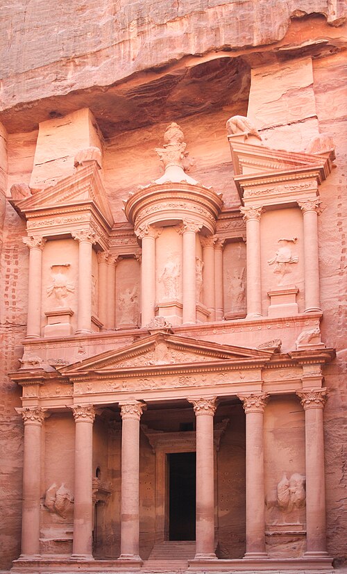
Imagine walking through a long, twisting crack in a mountain. The rock walls rise so high on both sides that you can only see a thin strip of sky. After more than a kilometre, the crack opens, and in front of you is a giant building with columns and statues, as tall as a twelve-storey tower. But it was not built from bricks. It was carved out of the cliff itself, like a sculpture. This is the Treasury, and it is the first thing most visitors see in Petra.
Petra was the home of a people called the Nabataeans. More than 2,000 years ago they were traders. Their camel caravans carried precious things like frankincense and myrrh, sweet-smelling tree resins that people burned in temples, across the desert from Arabia to the cities by the Mediterranean Sea. Petra was like a busy stopover and a treasure house at the same time.
Petra lies in a very dry place, where rain falls only a few times a year. So how did thousands of people live there? The Nabataeans were clever water engineers. They cut channels into the rock, built dams and dug big underground tanks called cisterns to catch every drop of rain and to keep sudden floods from washing the city away.
Later, the Romans took over Petra. Earthquakes knocked many buildings down, trade moved elsewhere, and people slowly left. For hundreds of years only local Bedouin families knew the way in. In 1812 a Swiss traveller named Johann Ludwig Burckhardt, dressed as a local traveller and speaking Arabic, reached Petra and told the world about it.
Today Petra is a World Heritage Site, and around a million people visit it in a busy year. That brings jobs, but feet, floods, wind and salt slowly wear away the soft stone. Keeping Petra safe is a big puzzle that archaeologists, the government of Jordan and local people are still working on together.
At a glance
- Location
- Wadi Musa area, Ma’an Governorate, southern Jordan, among sandstone mountains east of the Wadi Araba
- Builders
- The Nabataeans, an Arab people who controlled incense and spice caravan routes
- Main period
- First recorded in 312 BC; capital of the Nabataean kingdom from about the 2nd century BC; monumental peak 1st century BC–1st century AD
- Roman rule
- Annexed in AD 106 under Trajan; became part of the province of Arabia (Arabia Petraea)
- Famous monuments
- The Siq gorge, al-Khazneh (“the Treasury”), the Royal Tombs, the Theatre, the Great Temple, Qasr al-Bint and ad-Deir (“the Monastery”)
- Material
- Soft, multicoloured sandstone, mostly carved rather than built
- Rediscovered for Europe
- 22 August 1812 by Johann Ludwig Burckhardt
- Status
- UNESCO World Heritage Site (inscribed 1985); one of the “New Seven Wonders” in a 2007 public vote
Easy
What is Petra?
Petra is the ruin of an ancient city in southern Jordan, hidden in a basin surrounded by jagged sandstone mountains. Its name is Greek and simply means “rock”. The people who built it, the Nabataeans, called it Raqmu, a name that appears in their own inscriptions. The modern town of Wadi Musa, “the Valley of Moses”, lies just outside the main entrance.
What makes Petra famous is the way its builders used the landscape. Instead of putting up buildings from blocks, they often carved them directly into the cliffs. Hundreds of rock-cut façades line the valley walls: tombs, halls for ritual meals, shrines and houses. Down on the valley floor there were also free-standing buildings of cut stone, including temples, a colonnaded street, markets and baths, most of which are now collapsed.
For several centuries Petra was the capital of the Nabataean kingdom, a state that controlled the desert trade routes between Arabia, Egypt, Syria and the Mediterranean coast. At its height, in the 1st century AD, estimates of its population range from about 20,000 to 30,000 people, although such numbers are educated guesses rather than census figures.
Petra was inscribed on the UNESCO World Heritage List in 1985. The protected area is huge — about 26,000 hectares, or some 260 square kilometres — and it contains much more than the famous monuments near the main path. Archaeologists often say that only a small part of the ancient city has been excavated.
Easy
How to “read” Petra: a walk from the Siq to the Monastery
Petra is best understood as a journey. Visitors begin at Bab al-Siq, “the Gate of the Siq”, where the first large tombs and big stone blocks called djinn blocks stand beside the path. Then the path enters the Siq itself: a narrow, winding gorge about 1.2 km long. In places it is only about three metres wide, and its walls tower far above. The Siq was not cut by people; it is a natural crack in the mountain made by movements of the Earth’s crust and later smoothed by water. The Nabataeans paved it, lined it with water channels and carved small niches for sacred stones along its walls. Excavations in 1998 revealed the remains of a relief of two merchants leading camels, a reminder of what made the city rich.
At the end of the Siq the gorge opens suddenly onto al-Khazneh, “the Treasury”. The contrast between the dark, narrow passage and the glowing façade is almost theatrical, and many scholars think this effect was intended. The Treasury is about 39 m high and 25 m wide. Its two storeys are covered with columns, a broken pediment, a round kiosk-like structure called a tholos, and relief figures: horsemen usually identified as the twins Castor and Pollux below, dancing Amazons with axes above, and a female figure at the centre often identified with Isis or the goddess al-Uzza. Inside there are only plain, undecorated rooms.
Beyond the Treasury, the valley widens into the so-called Street of Façades, lined with tombs whose tops are decorated with rows of steps (the “crow-step” motif). Next comes the Theatre, carved into the hillside, which is estimated to have seated around 8,500 people. On the eastern cliff opposite rise the Royal Tombs — the Urn Tomb, the Silk Tomb, the Corinthian Tomb and the Palace Tomb — a giant row of façades, some with bands of pink, yellow and white stone running through them like marbled silk.
The path then turns west along the Colonnaded Street, the city’s main avenue, past the Great Temple and a garden-and-pool complex, to Qasr al-Bint, a large free-standing temple built of masonry. From there a stepped path of roughly 800 rock-cut steps climbs into the mountains to ad-Deir, “the Monastery”, one of Petra’s largest façades, about 47–48 m in height and width. Along the way and on nearby summits are ‘high places’: open-air platforms where the Nabataeans performed sacrifices and rituals.
Reading Petra means noticing three things: the city was designed around movement and sudden views; tombs, temples and dining halls were mixed together, so the dead and the gods were part of urban life; and the architecture blends local traditions with Greek, Egyptian and Near Eastern ideas.
Easy
How were the façades carved?
Petra’s rock is sandstone, which is soft enough to cut with iron tools but strong enough to hold its shape. Nabataean stonecutters did not build scaffolding up the whole height of a cliff first. The usual explanation, based on unfinished façades at Petra and at Hegra in Saudi Arabia, is that they worked from the top down. They first smoothed the cliff face, cut steps or a ledge to reach the top, carved the highest details, and then worked downward, removing rock as they went. The ground they stood on was the rock they had not yet cut away.
This method means that mistakes were hard to fix. A wrongly cut capital could not simply be replaced. It also means that the columns on a façade support nothing: they are sculpture, not structure. Behind many grand façades lie simple rectangular rooms, sometimes with burial niches (loculi) cut into the walls.
The façades we see today are bare stone, but they did not always look this way. Traces of plaster (stucco) and paint survive in places, and archaeologists think that many surfaces were once finished with coloured plaster, which would have hidden the natural stripes of the sandstone. Free-standing buildings such as Qasr al-Bint used dressed stone blocks, lime mortar and even wooden beams laid within the walls. The wood, which radiocarbon analysis has helped date, may have helped the building survive earthquakes by absorbing some of the shaking.
Nabataean craftsmen also developed their own plain version of the classical column capital, often called the Nabataean capital. At the Great Temple, excavators found capitals decorated with elephant heads, a striking sign of how widely the Nabataeans borrowed and adapted ideas.
Intermediate
An artificial oasis: water engineering
Petra receives very little rain, and much of it falls in short, violent storms. The problem for its inhabitants was twofold: to store enough water for the dry months, and to protect the city from flash floods that could rush down the narrow valleys with enormous force. The Nabataeans solved both problems with a network of dams, terraces, channels, pipes and cisterns that turned the basin into what is often called an artificial oasis.
The most visible part of the system is in the Siq. Channels cut into the gorge walls, and pipes of fired clay set into them, carried water from springs outside the city, including the spring of ʿAin Musa, toward the centre. At the entrance, a dam and a tunnel diverted the floodwaters of the Wadi Musa away from the Siq and around the mountain. The modern dam at the same spot, rebuilt in 1963 and again in 1991, follows the logic of the ancient one.
Across the whole site, hundreds of cisterns — some open basins, others roofed underground chambers — stored rainwater that ran off the bare rock. Terrace walls in the side valleys slowed runoff and allowed farming. In the city centre, excavations revealed a large pool with an island pavilion and a garden, once identified as a market. Keeping a pool of open water in the middle of the desert was a deliberate display of wealth and control over nature.
Water management explains both Petra’s rise and its vulnerability. When the channels were maintained, the city could support a large population and impressive public spaces. When earthquakes damaged the system, as in AD 363, and when there was less money and labour to repair it, life in the city became harder. Modern conservators have revived parts of the ancient drainage system because the same floods that threatened Petra 2,000 years ago still threaten visitors and monuments today.
Intermediate
The Nabataeans: from desert traders to kings
The Nabataeans were an Arab people who appear in written history in the late 4th century BC. The Greek historian Diodorus of Sicily, writing in the 1st century BC but drawing on an earlier source, describes them in the context of events in 312 BC. In his account they were nomads who lived in the open desert, did not build houses, and guarded the secrets of their water sources. In that year Antigonus I, one of the generals who divided Alexander the Great’s empire, sent an army under his officer Athenaeus to raid them at a rocky stronghold. The raiders seized goods while the men were away, but the Nabataeans pursued and destroyed the force. Whether this “rock” was Petra itself is debated, and it is not clear that a town existed there at that time.
Over the next two centuries the Nabataeans became settled, wealthy and organized as a kingdom. The first king named in the sources is Aretas I, mentioned around 169–168 BC. Later rulers included Obodas I, who defeated the Hasmonean king Alexander Jannaeus in about 93 BC and was worshipped as a god after his death; Aretas III, under whom the kingdom reached as far as Damascus; and Aretas IV (ruled 9 BC–AD 40), whose long reign coincided with Petra’s greatest building boom. The last king, Rabbel II, died in 106.
Their wealth came from trade. The Nabataeans controlled caravan routes that carried frankincense and myrrh from southern Arabia, and spices and other luxury goods arriving from India, north to Gaza on the Mediterranean, to Damascus and to Egypt. They supplied water, guides, security and markets along the way, and they collected tolls. Their kingdom included towns such as Bosra in the Hauran, Hegra (Mada’in Salih) in the Hijaz, and settlements in the Negev such as Avdat and Mamshit.
Nabataean society was multilingual. People seem to have spoken a form of Arabic, but they wrote official inscriptions in Aramaic, the international language of the Near East. Their Aramaic script developed a distinctive cursive form, and most scholars agree that the Arabic alphabet later grew out of it. Nabataean coins portray queens as well as kings, and inscriptions record women owning tombs, which suggests that elite women had a visible legal and public role.
Relations with Rome were long and complex. In 62 BC the Roman commander Marcus Aemilius Scaurus besieged Petra, and Aretas III agreed to pay tribute. From then on the kingdom was a client state under Roman influence, often entangled in the politics of neighbouring Judaea.
Intermediate
Gods, tombs and feasting: religion at Petra
The chief Nabataean god was Dushara (often written Dushares in Greek), whose name is usually understood as “the one of the Shara”, the mountain range around Petra. He enjoyed special royal patronage. Female deities were also important, especially al-Uzza, often linked with the Greek Aphrodite or the Egyptian Isis, and Allat. At first the Nabataeans represented their gods mainly as plain standing stones or blocks, sometimes with only simple eyes or none at all. These stones, called baetyls, can still be seen in niches along the Siq and elsewhere. Under Greek and Roman influence, gods were increasingly shown in human form.
Worship took place in many settings: open-air high places on mountain tops, where there are altars, basins and channels for liquids; niches and shrines along roads; and large temples in the city centre, such as Qasr al-Bint. Which god Qasr al-Bint served is still debated; Dushara is the most common suggestion, but Greek inscriptions and a baetyl fragment have prompted other proposals.
Death was also a central part of religious life. Most of Petra’s rock-cut façades are tombs, and many tomb complexes included courtyards, cisterns and dining rooms (triclinia or biclinia) with benches cut into the rock. Families and associations seem to have gathered there for ritual meals in honour of the dead and the gods. An inscription at ad-Deir refers to a mrzḥ (marzeah), a type of religious association or banquet, connected with “Obodat the god”, probably the deified king Obodas I. This suggests that ad-Deir served for gatherings rather than as a tomb.
Intermediate
Roman province, Byzantine city, medieval ruin
In AD 106, after the death of King Rabbel II, the Nabataean kingdom was annexed by Rome under the emperor Trajan, while Aulus Cornelius Palma was governor of Syria. It became the province of Arabia, often called Arabia Petraea. The sources say little about how the annexation happened, and whether there was fighting is uncertain. Coins celebrated the new territory, and Trajan built a road, the Via Nova Traiana, running from Bosra through Petra to the Red Sea at Aila (Aqaba).
Petra did not collapse under Rome. It received the title metropolis, and when the emperor Hadrian visited in 130 the city took the name Hadriana Petra. But Bosra became the main seat of provincial government, and over time more goods travelled by sea through the Red Sea and Egypt.
A major earthquake in 363 destroyed many buildings and damaged the water system. Yet the city lived on. Under Byzantine rule Petra became the seat of a bishop and a leading city of the province of Palaestina Tertia. In 446 the Urn Tomb was converted into a church. Excavations of the so-called Petra Church, with its fine floor mosaics, and a nearby building revealed about 140 carbonized papyrus rolls in 1993. Written in Greek and dating to the 6th century, the Petra papyri are mostly the archive of one wealthy family, centred on a deacon named Theodoros, and record marriages, inheritances, property sales and tax matters. They show that Petra was still an active town in the 500s.
After the Islamic conquests of the 7th century, Petra appears only rarely in written sources, and it gradually shrank to a small settlement. In the 12th century the Crusaders built small forts in the area, including al-Wuʿayra near Wadi Musa and another on the summit of al-Habis inside Petra, which they later lost. In the late 13th century the Mamluk sultan Baybars passed through and visited the ruins. After that, Petra disappeared from European knowledge, although it was never truly ‘lost’: local Bedouin lived among the monuments and knew them well.
Intermediate
Burckhardt, artists and archaeologists
Johann Ludwig Burckhardt (1784–1817), born in Lausanne, was a traveller in the service of the African Association in London, which hoped he would eventually cross the Sahara. He studied Arabic and Islam in Syria and travelled under the name Sheikh Ibrahim ibn Abdallah. In August 1812, on his way from Damascus to Cairo, he heard about remarkable ruins in the Wadi Musa. Explaining that he wished to sacrifice a goat at the tomb of the prophet Aaron (Harun) on a nearby mountain, he persuaded a local guide to take him through the valley. On 22 August he saw the Treasury and other monuments. He could not stay long or take notes openly, because his interest would have aroused suspicion. His account was published after his death in Travels in Syria and the Holy Land (1822).
Burckhardt opened the way for others. In 1828 Léon de Laborde and Louis-Maurice-Adolphe Linant de Bellefonds made the first accurate drawings. The Scottish painter David Roberts visited in 1839, and his lithographs made Petra’s rose-red cliffs famous in Europe. Later travellers, photographers and painters, such as the American Frederic Edwin Church in 1868, added to its romantic image. In the 20th century films such as Indiana Jones and the Last Crusade (1989) made the Treasury one of the most recognizable ancient façades in the world.
Scientific archaeology began slowly. In 1929 the British archaeologists Agnes Conway and George Horsfield, with the Palestinian physician and ethnographer Tawfiq Canaan and the Danish scholar Ditlef Nielsen, carried out early excavations and surveys. After Jordan’s independence, the Department of Antiquities of Jordan and many foreign teams took up the work. Major projects included the excavation of the Great Temple by Brown University under Martha Sharp Joukowsky from 1993, the excavation of the Petra Church by the American Center of Oriental Research in the 1990s, and long-term work by teams from many countries on houses, temples, tombs and water systems.
Discoveries continue. In 2003 excavators working in front of the Treasury found tombs cut below its present ground level, showing that the façade once stood higher above the valley floor. Surveys using satellite images and drones keep locating structures that are invisible from the ground.
Advanced
Debates: dates, functions and the shape of the city
Very few of Petra’s monuments carry dated inscriptions, so their chronology depends on stylistic comparison, stratigraphy and occasional scientific dates. The Treasury is the classic example. Many scholars now place it at the turn of the era, in the reign of Aretas IV, and some suggest it was his tomb, but proposals over the past two centuries have ranged from the 1st century BC to the Roman period of the 2nd century AD. Judith McKenzie’s The Architecture of Petra (1990) was an influential attempt to build a relative sequence of façades by analysing their classical ornament and comparing it with dated architecture in Alexandria and elsewhere; her framework is widely used but not universally accepted, and new excavations continue to refine it.
Function is just as contested. Was the Treasury a royal tomb, a temple, or a monument combining both roles? Its plain interior rooms and the tombs found beneath it support a funerary reading, but its sculpture — gods, Amazons, the central female figure — suggests broader religious meaning. The Great Temple, excavated by Brown University, contains a small theatre-like auditorium of roughly 600 seats inside the building. Its excavators and other scholars have debated whether it was a temple, a council chamber, a royal audience hall or an administrative centre. Ad-Deir’s inscription referring to a feasting association of the deified Obodas points to communal ritual, but its exact role is still discussed.
A broader debate concerns the nature of Nabataean culture itself. Earlier writers sometimes described Petra as a Hellenized or Romanized city, imitating Mediterranean fashions. More recent research emphasizes Nabataean agency: local patrons chose Greek, Egyptian and Mesopotamian elements and combined them with Arabian traditions such as baetyls, crow-step façades and feasting halls, creating something new. The same debate affects the history of writing, since the Nabataean script is a key link in the development of the Arabic alphabet.
Finally, there is the question of what the city as a whole looked like. The tourist route passes mainly through the monumental centre, but surveys show a much larger landscape of houses, farms, quarries and water installations. Population estimates of 20,000–30,000 are rough and depend on assumptions about housing density and water supply.
Advanced
Conservation, tourism and the Bdul: who is Petra for?
Petra’s beauty is also its weakness. Sandstone is porous and soft. Salts carried by moisture crystallize inside the stone and flake off its surface; wind blows sand against the façades; flash floods scour the valleys. Earthquakes have repeatedly damaged the site. Added to these natural threats are human ones: the collapse of unmaintained structures, poor drainage, restoration work that used unsuitable materials, and the sheer pressure of visitors. Surveys of the site’s condition commonly list collapse, erosion from flooding and poor drainage, weathering from salt, improper restoration and unsustainable tourism as the main risks.
Tourism grew dramatically after the 1990s, passing one million visitors in 2019, although numbers fall sharply in years of regional conflict or, as in 2020, the pandemic. Tourism supports thousands of jobs in Wadi Musa and nearby villages, but crowds wear down steps and floors, and hotels press against the edges of the protected area. The Petra National Trust, founded in 1989, Jordan’s Department of Antiquities and international partners have restored the Siq paving, rebuilt parts of the ancient flood-control system and stabilized monuments. The use of donkeys and camels to carry tourists has also drawn criticism on animal-welfare grounds.
The most sensitive question concerns the Bdul (also spelled Bedul), a Bedouin tribe who lived for generations in caves and tents inside Petra, farming, herding and later working in tourism. Their origin traditions vary: some accounts link them to the ancient Nabataeans, others to earlier or different ancestors, and the anthropologist Kenneth W. Russell has studied how these stories were used. Around the time Petra was inscribed on the World Heritage List in 1985, the Jordanian government relocated about 140 Bdul families to a new village, Umm Sayhoun, about 10 km away (sources differ on the exact distance), which offered houses, schools, clinics, electricity and running water.
Assessments of the relocation differ. Supporters argue that it protected the monuments and gave families modern services. Critics point out that it separated people from a landscape that was their home and livelihood, that the village soon became overcrowded, and that local communities have not always shared fairly in tourism income or decision-making. Reports of further removals of residents from the area in 2024 show that the issue is not settled. The Petra case is now often discussed in heritage studies as an example of the tension between protecting monuments and respecting the rights and knowledge of the people who live with them.
Key ideas
- Rock-cut architecture
- Buildings made by removing stone from a cliff rather than stacking blocks. At Petra, façades were usually carved from the top down, so columns and pediments are sculpture, not load-bearing structure.
- Caravan economy
- Petra’s wealth came from controlling and servicing desert trade routes for incense, spices and luxury goods — providing water, protection and markets, and collecting tolls.
- Water as power
- Dams, channels, cisterns and pools let the Nabataeans live in the desert, protect the city from flash floods and even display luxury, such as an open-air pool and garden in the city centre.
- Cultural blending
- Nabataean builders combined Arabian traditions (sacred stones, crow-step motifs, feasting halls) with Greek, Egyptian and Mesopotamian forms, choosing and adapting rather than simply copying.
- Landscape as theatre
- The Siq’s dark, winding passage and the sudden view of the Treasury show how Petra’s builders used natural topography for dramatic effect.
- A long afterlife
- Petra did not vanish in 106: it continued as a Roman and Byzantine city, housed churches and a papyrus archive, attracted Crusader forts, and remained home to Bedouin communities.
- Living heritage
- Modern conservation must balance fragile stone, mass tourism and the rights of local people such as the Bdul, making Petra a key case in debates about who heritage belongs to.
Records
- 312 BCE — Antigonus I sends raids against the Nabataeans at a rocky stronghold — the first historical mention of the Nabataeans, recorded by Diodorus of Sicily (312 BC).
- c. 169 BCE — Aretas I, the first Nabataean ruler named in the sources, is mentioned (c. 169–168 BC).
- 62 BCE — The Roman commander Marcus Aemilius Scaurus besieges Petra; Aretas III agrees to pay tribute (62 BC).
- 9 BCE — Aretas IV begins his long reign (9 BC–AD 40), the period of Petra’s greatest building activity; the Treasury is commonly dated to around this time.
- 106 CE — After the death of Rabbel II, Rome annexes the Nabataean kingdom under Trajan, creating the province of Arabia.
- 363 CE — A major earthquake destroys many buildings and damages the water system.
- 446 CE — The Urn Tomb is converted into a church, reflecting Petra’s Christian Byzantine period.
- c. 1100 — Crusaders build small forts at al-Wuʿayra and on al-Habis in the 12th century.
- 1812 — On 22 August, Johann Ludwig Burckhardt becomes the first modern European known to have visited Petra.
- 1929 — Agnes Conway, George Horsfield, Tawfiq Canaan and Ditlef Nielsen carry out early excavations and surveys.
- 1985 — Petra is inscribed on the UNESCO World Heritage List; around the same time about 140 Bdul families are relocated to Umm Sayhoun.
- 1993 — About 140 carbonized 6th-century papyri are found in the Petra Church; excavation of the Great Temple begins.
Glossary
- Nabataeans
- An Arab people who controlled desert trade routes and ruled a kingdom centred on Petra from roughly the 2nd century BC until AD 106.
- Siq
- The narrow natural gorge, about 1.2 km long, that forms the main entrance to Petra.
- Al-Khazneh
- Arabic for “the Treasury”; Petra’s most famous rock-cut façade, named after a local legend that treasure was hidden in the stone urn at its top.
- Baetyl
- A sacred standing stone or block used to represent a god, common in Nabataean religion.
- Dushara
- The chief god of the Nabataeans, associated with the mountains around Petra and with the royal family.
- High place
- An open-air sanctuary on a hill or mountaintop, with altars and basins for sacrifice and offerings.
- Triclinium / biclinium
- A dining room with benches on three (or two) sides, used at Petra for ritual banquets connected with tombs and gods.
- Tholos
- A round, columned structure; on the Treasury it forms the centrepiece of the upper storey.
- Cistern
- A tank, often cut into rock, for storing rainwater.
- Arabia Petraea
- The Roman province of Arabia created in AD 106 from the Nabataean kingdom.
- Bdul
- A Bedouin tribe that lived inside Petra for generations and was relocated to the village of Umm Sayhoun in the 1980s.
Questions and answers
Why is Petra called the “rose-red city”?
Because much of its sandstone glows pink and red, especially in the morning and evening light. The phrase comes from a 19th-century English poem and is poetic rather than exact: the rock also shows yellow, white, purple and brown bands.
Is there really treasure in the Treasury?
No. The name comes from a local legend that riches were hidden in the stone urn at the top of the façade. Bullet marks on the urn are attributed to people who tried to shoot it open. The building was most likely a royal tomb or a monument with a religious function.
How did people carve such huge buildings without machines?
With iron chisels, picks and a great deal of skill and planning. Stonecutters usually started at the top of the cliff and worked downward, standing on the uncut rock below them.
Was Petra ever really “lost”?
Only to Europeans. Local Bedouin knew and used the site continuously, and medieval travellers such as the Mamluk sultan Baybars visited it. Burckhardt’s 1812 visit introduced it to European scholarship.
Did the Romans destroy Petra?
No. Rome annexed the kingdom in 106, and the city continued to prosper for some time. Its decline was gradual and linked to changing trade routes, the rise of other regional centres and earthquakes, especially in 363.
How secure is the dating of Petra’s monuments?
Not very. Few façades have dated inscriptions, so dates rely on stylistic analysis, excavation layers and some scientific methods. The Treasury, for example, is commonly placed around the reign of Aretas IV, but earlier and later dates have been proposed.
What happened to the people who lived in Petra’s caves?
Many Bdul families were moved by the Jordanian government to the new village of Umm Sayhoun in the 1980s. The relocation brought modern services but also loss of homes and livelihoods, and it remains debated.
Sources and further reading
- Petra. Wikipedia
- Nabataean Kingdom. Wikipedia
- Al-Khazneh. Wikipedia
- Siq. Wikipedia
- Ad Deir. Wikipedia
- Great Temple (Petra). Wikipedia
- Petra papyri. Wikipedia
- Johann Ludwig Burckhardt. Wikipedia
- Bedul. Wikipedia
- Judith McKenzie, The Architecture of Petra. Oxford University Press (British Academy Monographs in Archaeology), 1990
Related
- PersepolisA ceremonial and administrative center of the Achaemenid Empire in southwestern Iran, begun under Darius I.
- Obelisk of AxumA carved stone funerary monument from the ancient kingdom of Aksum in present-day Ethiopia.
- Rock-Hewn Churches of LalibelaEleven churches carved downward out of solid volcanic rock in the Ethiopian highlands, traditionally under the Zagwe king Gebre Meskel Lalibela, as a symbolic “New Jerusalem” that remains a centre of Ethiopian Orthodox pilgrimage.
- Ajanta CavesA group of Buddhist rock-cut caves in western India, known for monasteries, shrines and paintings.
- PantheonA Roman temple rebuilt under Hadrian, celebrated for its vast concrete dome and central opening.
- Library of AlexandriaAn ancient center for collecting and studying texts in Ptolemaic Alexandria.
Written with AI assistance from the published sources listed above, and revised as new research appears.