Start at the top for an easy introduction. Go further down for more detail and scholarship.
- Easy
- Intermediate
- Advanced
For young readers
Imagine a desert so dry that it almost never rains. The ground is covered with small dark reddish stones. If you pick up the stones and pile them along the edges, you uncover a strip of pale yellow earth underneath. Now you have drawn a line, and because there is almost no rain or strong wind, that line can last for hundreds and even thousands of years.
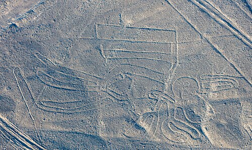
That is exactly what the people of the Nazca culture did in southern Peru. They drew straight lines that run for kilometres, big triangles and long trapezoid shapes, spirals and zigzags. They also drew animals and plants: a hummingbird, a monkey with a curly tail, a spider, a condor, a killer whale, flowers and trees. Some drawings are as long as a football field or longer.
Many of the pictures are so big that you cannot really see them well when you stand beside them. From the nearby hills, or from an aeroplane, they suddenly make sense. That is why many people ask: how did they draw them so neatly without flying? The answer seems to be simple tools: wooden stakes, string, careful measuring and lots of teamwork. People today have tried it and managed to draw big figures in just a few days.
Nobody knows for sure why the lines were made. Scientists think they had to do with water, which was the most precious thing in the desert, and with ceremonies. People may have walked along the lines in processions, like following a path in a big outdoor temple, and left broken pots as gifts.
Today the Nazca Lines are a World Heritage Site. They are fragile: a single car or even footprints can scar them for centuries. So visitors look at them from towers, hills and small planes instead of walking on them.
At a glance
- Made
- Roughly 500 BCE to 500 CE; the Paracas culture began the tradition and the Nazca culture (c. 100 BCE–800 CE) made most of the famous figures
- Place
- Desert plateaus (pampas) between the towns of Nazca and Palpa, Ica Region, southern Peru, about 400 km south of Lima
- Kind
- Geoglyphs: designs made on the ground surface, including straight lines, geometric shapes and animal and plant figures
- Technique
- Removing the dark, iron-oxide-coated surface stones to expose the lighter subsoil beneath; lines are usually only 10–15 cm deep
- Scale
- Lines with a combined length of over 1,300 km across roughly 50 km² of the pampa; the largest figures span several hundred metres
- Famous figures
- Hummingbird (about 93 m long), monkey (about 93 × 58 m), condor (about 134 m), spider (about 47 m)
- Status
- UNESCO World Heritage Site since 1994 (Lines and Geoglyphs of Nasca and Palpa)
- Purpose
- Debated; leading ideas connect the lines with water, ritual walking and pilgrimage, and social or kin groups
Easy
What are the Nazca Lines?
The Nazca Lines are a vast group of geoglyphs, designs made on the surface of the earth, in the coastal desert of southern Peru. They lie on the flat, stony plateaus called pampas between the river valleys around the modern towns of Nazca and Palpa. The name comes from the Nazca (or Nasca) culture, the ancient people who made most of them, and from the town and river that carry the same name today.
The geoglyphs fall into three broad groups. The most numerous are straight lines, some running almost perfectly straight for several kilometres across hills and dry riverbeds. Then there are geometric figures: long trapezoids and triangles, spirals, zigzags and rectangles. Finally there are the figures that made the site famous: animals, plants and a few human-like beings, the so-called biomorphs. On the main pampa there are roughly seventy of these large animal and plant figures, while more recent surveys have added hundreds of smaller figures on hillsides and along ancient footpaths.
Taken together, the lines stretch for more than 1,300 km and cover an area of about 50 km². The World Heritage Site that protects them is much larger, because it also includes the surrounding landscape and the hillside geoglyphs near Palpa.
The lines were not made all at once. Archaeologists date them over about a thousand years, from roughly 500 BCE to 500 CE. The earliest, many on hillsides near Palpa, belong to the Paracas culture; most of the famous figures on the flat pampa belong to the Nazca culture that followed.
Easy
How to “read” the drawings
The best-known figures are animals. The hummingbird is about 93 m long, with long straight wings and a needle-like beak. The monkey, about 93 by 58 m, has a tail that curls into a spiral. The spider is about 47 m long. The condor, with outspread wings, measures about 134 m. There are also a killer whale, a lizard, a heron-like bird, a dog, flowers, a tree and a pair of hands. On a steep hillside stands a round-headed figure about 30 m tall, often nicknamed “the astronaut” or “the owl-man”.
Many of these big animal figures share a surprising feature: they are drawn with a single continuous line that does not cross itself. The line leads in from one side, traces the whole outline of the animal, and leads out again. This suggests that the figures were not only pictures to be looked at but paths to be walked. A person walking the outline of the hummingbird would move around the entire bird and come out where they began.
The straight lines often radiate out from low natural hills or mounds, which archaeologists call line centres or ray centres. From one such centre a dozen or more lines can spread out in different directions like the spokes of a wheel. Some lines lead toward rivers, water sources or mountains; others connect one line centre to another.
The trapezoids are some of the largest geoglyphs of all, sometimes hundreds of metres long. They are wide at one end and narrow at the other, and many are oriented toward the river valleys, where water flowed in the rainy season in the Andes. Their large, cleared surfaces could have held gatherings of many people.
Easy
How were they made?
The desert surface near Nazca is covered with a layer of small stones that have been darkened over time by a reddish-brown coating of iron oxide, a kind of natural rust. Just beneath them lies lighter, yellowish-grey soil. To make a line, people picked up or raked away the dark stones and piled them along the edges. This created a pale strip, often only 10–15 cm deep, framed by low ridges of stones. Many lines are about 30 cm wide, but some are almost 2 m wide and the trapezoids are far broader.
Making the figures required planning, not magic. Archaeologists have found remains of wooden stakes at the ends of some lines, which suggests people used stakes and cords to lay out straight segments. A small sketch could be enlarged with a grid, or with a system of measured cords and fixed points. In 1982 the American investigator Joe Nickell and a small team reproduced the 134 m condor figure in a field in Kentucky using only wooden stakes, string and simple measuring methods, with no aerial view, in a couple of days.
The climate explains why the lines survived. The Nazca pampa is one of the driest places on earth. Rain is extremely rare, and the stony surface soaks up heat, creating a cushion of warm air that reduces wind at ground level. The lime-rich subsoil also hardens slightly when the morning mist touches it. As a result, a line cleared two thousand years ago can remain visible today, unless modern people damage it.
Intermediate
The people who made them: Paracas and Nazca
Before the Nazca, the south coast of Peru was home to the Paracas culture (roughly 800 BCE to 100 BCE), famous for its complex textiles and burials on the Paracas Peninsula. In the Palpa area, archaeologists have identified geoglyphs made by Paracas communities: human-like figures, often interpreted as warriors or supernatural beings, carved into the hillsides where they could be seen from the valleys below. Some of these are centuries older than the famous Nazca figures on the pampa.
The Nazca culture grew out of the Paracas tradition around 100 BCE and flourished until about 800 CE. The Nazca did not build a single empire with a capital city. They lived in villages in the river valleys, farmed maize, beans, squash, cotton and other crops, and fished along the coast. They were superb potters, painting their vessels with at least a dozen colours and a rich world of images: birds, fish, killer whales, plants, warriors, trophy heads and mythical beings. Several of these images, such as hummingbirds and killer whales, also appear on the pampa.
The most important religious site of the early Nazca period was Cahuachi, in the Nazca Valley, a group of adobe mounds and plazas in use roughly from 1 to 500 CE. Research by the archaeologists Helaine Silverman and Giuseppe Orefici has shown that Cahuachi was not a city but a ceremonial centre: its population rose sharply at festival times, when people from the surrounding valleys gathered there. Cahuachi overlooks part of the pampa, and many scholars see the geoglyphs and the centre as parts of one sacred landscape.
Water was the heart of Nazca life. The rivers that come down from the Andes often run dry for much of the year. The Nazca region is also known for puquios, underground channels and spiral-shaped access wells that tap groundwater, several dozen of which still supply water today. Many archaeologists date them to the later Nazca period, around 500 CE, but others argue that they were built or reshaped after the Spanish conquest; their age is still debated.
Intermediate
Why were they made? The main theories
Astronomy. The first scholars to study the lines closely thought they were an enormous calendar. In 1941 the American historian Paul Kosok noticed that the sun set along one line on the day of the winter solstice in the Southern Hemisphere. The German-born mathematician Maria Reiche, who worked with Kosok and then devoted the rest of her life to the lines, developed this into the theory that the lines marked the rising and setting points of the sun, moon and stars. Later tests by the astronomers Gerald Hawkins and Anthony Aveni found that the number of lines pointing to astronomical events was no greater than would be expected by chance, so few scholars now think astronomy was the main purpose, though some individual alignments may have mattered.
Water and fertility. Many researchers link the lines to the search for water. The anthropologist Johan Reinhard argued in the 1980s that the lines were part of a widespread Andean religion centred on mountains and water, and that walking the lines and the figures was a way of asking for water and fertility. Some lines point toward sources of water or toward the mountains from which rivers flow. The researcher David Johnson proposed that some geoglyphs mark underground water courses feeding the puquios, but this more specific idea has not been widely confirmed.
Walking, ritual and pilgrimage. Because many figures are drawn with a single continuous line, and because the lines are covered with fragments of broken pottery, most archaeologists now think they were made to be walked, not to be seen from above. Processions may have moved along them during ceremonies, perhaps on the way to or from Cahuachi. Anthony Aveni and others have suggested that particular lines and line centres were built and maintained by particular kin or community groups, so that making and walking them was also a way of organizing society.
No single answer. It is likely that the lines meant different things at different times over a thousand years. A trapezoid used for gatherings, a straight line leading to a water source and an animal figure walked in a ritual may have had different purposes, even if they belonged to the same religious world.
Intermediate
Aliens, balloons and other myths
Because the figures are best seen from the air, the Nazca Lines have attracted fantastic explanations. The Swiss writer Erich von Däniken, in his bestselling Chariots of the Gods? (1968), suggested that the lines were landing strips or signals for extraterrestrial visitors. Archaeologists reject this idea completely. The lines are shallow scrapings in loose gravel that no aircraft could use, their creation can be reproduced with simple tools, and they are clearly connected with the art, pottery and religion of the local people.
Other popular theories have proposed that the Nazca flew in hot-air balloons to supervise the work. There is no archaeological evidence for this either. Many figures can actually be seen well from the surrounding foothills, and the Palpa hillside figures were made to be seen from the valley floor.
The appeal of these myths also carries a problem: they often assume that ancient people of the Americas could not have planned such works themselves. Modern research emphasizes the opposite, that the lines are an impressive achievement of Indigenous Andean knowledge, organization and religious imagination.
Intermediate
Rediscovery and research in the twentieth century
Local people had always known of the lines, and they were crossed by travellers for centuries. They became a subject of scientific study in the twentieth century. In 1927 the Peruvian archaeologist Toribio Mejía Xesspe noticed them while walking in the foothills and later interpreted them as sacred roads. Commercial flights over the area from the late 1920s made the patterns more widely known.
Paul Kosok studied the lines in 1940–41. Maria Reiche (1903–1998) began working with him in 1941 and continued for more than fifty years, measuring and mapping the figures, sweeping them clean and campaigning for their protection. She published The Mystery on the Desert in 1949 and used the income from it to support conservation, persuading the Peruvian authorities to restrict access. She lived for many years near the pampa, and her former home is now a museum.
From the 1980s, archaeologists and astronomers such as Anthony Aveni, Helaine Silverman and Johan Reinhard shifted attention from astronomy to walking, ritual, water and social organization. A German–Peruvian project led by Markus Reindel and Johny Isla carried out long-term research in the Palpa area, documenting hundreds of geoglyphs and excavating structures at the ends of some lines.
Intermediate
New discoveries with drones and artificial intelligence
Research did not end with the famous figures. Since the mid-2000s a team from Yamagata University in Japan, led by Masato Sakai, has surveyed the pampa systematically. It announced about one hundred new geoglyphs between 2006 and 2012, and in 2019 it reported 143 more, one of them found with the help of machine learning. In 2020 a large cat-like figure was revealed on a steep hillside when a viewing platform was being improved.
In 2024 the Yamagata team, working with IBM researchers, published a study reporting 303 previously unknown figurative geoglyphs found in about six months of fieldwork, guided by an AI model that scanned high-resolution aerial images for likely candidates. This nearly doubled the number of known figurative geoglyphs in the area. The new finds included parrots, cats, monkeys, killer whales and scenes that appear to show decapitated heads and domesticated animals.
These discoveries confirmed an important distinction. Line-type figures, the large outline drawings on the pampa, usually show wild animals and seem linked to ritual activity. Relief-type figures, made by removing stones from inside a shape rather than just outlining it, are much smaller (often under 10 m) and lie beside ancient footpaths, where travellers walking by could see them. The researchers suggest that the small relief figures shared information or messages with people on the trails, while the large line figures were ritual spaces used by communities.
Intermediate
Threats and conservation
The lines survived for two thousand years largely because nobody disturbed them. Modern life is far more dangerous. The Pan-American Highway, built across the pampa in the 1930s, cuts straight through the lizard figure. Tyre tracks from cars and motorbikes leave marks that may last as long as the lines themselves. Settlers, informal mining, quarrying and agriculture push into the edges of the protected area.
There have been several well-publicized incidents. In December 2014 activists from Greenpeace entered the area next to the hummingbird to lay out a message for a climate conference in Lima, leaving footprints in the fragile surface; the organization apologized. In 2018 a truck driver drove off the highway and left deep tyre marks across part of three geoglyphs. Off-road vehicles in rallies have damaged geoglyphs outside the core zone.
Peru's Ministry of Culture manages the site, with restricted access, guards, a roadside viewing tower and small-aircraft overflights for visitors. Climate change is an added worry: unusually heavy rains, such as those brought by strong El Niño events, could wash sediment over the lines or erode them.
Advanced
Scholarly debates: dating, function and the problem of the “view from above”
Dating. Geoglyphs are hard to date because they are made by removing material, not adding it. Archaeologists rely mainly on indirect evidence: the style of the figures compared with dated Paracas and Nazca pottery and textiles; pottery sherds lying on or beside the lines, which can be assigned to ceramic phases; excavation of stone structures, offerings and post holes at line ends; and, in some studies, scientific methods such as luminescence dating of buried surfaces or radiocarbon dating of associated organic material. The resulting chronology is broad: the hillside figures of Palpa are mostly Paracas, many pampa biomorphs are early Nazca, and many straight lines and trapezoids seem to be middle to late Nazca, though individual lines were reused and reshaped over time.
Seen or walked? Early research, driven by aerial photography, assumed that the figures were meant to be seen from the sky, by gods if not by people. Since the 1980s the emphasis has shifted to walking and use on the ground: single-line figures, pathways worn into line surfaces, pottery offerings, and the clustering of lines around places of water and assembly. The 2024 study of relief-type figures along trails adds a third perspective: some geoglyphs were made to be seen by walkers passing at close range. Many scholars now avoid a single model and speak of a landscape used in different ways by different groups over time.
Social organization. A central question is who made and maintained the lines. Because the Nazca had no single capital, the geoglyphs may have been produced by many small communities or kin groups (ayllu-like units in later Andean terms), each responsible for its own lines. This view, associated especially with Silverman and Aveni, treats the lines as a record of social relationships rather than a single grand plan. Critics note that the analogy with later Andean institutions, such as the Inca ceque system of lines radiating from Cusco, is suggestive but cannot be proven for a society a thousand years earlier.
Astronomy revisited. The statistical rejection of Reiche's calendar theory is widely accepted, but some researchers continue to argue for specific alignments or for connections between figures and dark patches in the Milky Way, which Andean peoples recognize as “dark cloud constellations”. These proposals remain minority views because they are difficult to test.
Advanced
Evidence and methods
Mapping. From the 1940s to the 1990s the lines were mapped with ground survey, measuring tapes and aerial photography. Today researchers use satellite imagery, drones, photogrammetry and airborne laser scanning (lidar), which can reveal faint or partly erased geoglyphs and measure their depth and profile. The recent AI-assisted survey shows how machine learning can narrow the search area, though every candidate still has to be checked on the ground.
Excavation. Excavation at the ends of lines and in trapezoids, especially in the Palpa region, has uncovered small stone platforms, post holes and offerings such as pottery, crops and marine shells. These finds support the idea that the geoglyphs were places of ritual action. Excavation at Cahuachi has revealed ceremonial architecture, offerings and burials that help place the pampa in its religious context.
Environment. Palaeoclimate studies of river sediments and pollen suggest that the Nazca lived in a landscape that became drier over time. Some researchers link the decline of the Nazca culture around 500–750 CE to a combination of drought, flooding caused by El Niño events and deforestation of native huarango trees (Prosopis), which exposed farmland to erosion. These environmental changes may help explain why the ritual focus on water was so strong.
Limits of the evidence. The Nazca left no writing, so there is no text explaining the lines. Every interpretation depends on archaeology, analogy with later Andean cultures documented after the Spanish conquest, and the careful study of the geoglyphs themselves. This is why caution and a willingness to hold several hypotheses at once are hallmarks of good Nazca scholarship.
Key ideas
- Geoglyph
- A large design made on the ground, either by removing surface material (as at Nazca) or by arranging stones; the Nazca Lines are the most famous examples.
- Sacred landscape
- The idea that the lines, the ceremonial centre of Cahuachi, the rivers and the mountains formed one religious space rather than separate monuments.
- Water and fertility
- In one of the driest places on earth, many lines seem connected with rituals asking for water and good harvests.
- Walking the lines
- Single-line figures, worn paths and pottery offerings suggest the geoglyphs were made to be walked in ceremonies, not only seen from above.
- Community labour
- The lines were made with simple tools by many people over centuries, possibly by different kin or community groups, each responsible for its own lines.
- Line and relief figures
- Large outline figures on the pampa seem ritual; small relief figures beside footpaths seem designed to be seen by passing travellers.
- Fragility
- Lines that survived two thousand years can be destroyed in minutes by a vehicle, so conservation depends on keeping people off the surface.
Records
- c. 400 BCE — Paracas communities begin making geoglyphs, many on hillsides near Palpa (Paracas phase roughly 400–200 BCE).
- c. 100 BCE — The Nazca culture emerges from the Paracas tradition on the south coast of Peru.
- c. 1 CE — Cahuachi becomes the main ceremonial centre of the Nazca Valley (in use until about 500 CE).
- c. 500 CE — The main period of line-making on the pampa draws to a close.
- c. 750 CE — The Nazca culture declines, amid drought, floods and deforestation; highland Wari influence grows.
- 1927 — Peruvian archaeologist Toribio Mejía Xesspe studies the lines, which he interprets as sacred roads.
- 1941 — Paul Kosok observes a solstice alignment; Maria Reiche begins her decades of work on the lines.
- 1949 — Maria Reiche publishes The Mystery on the Desert.
- 1968 — Erich von Däniken's Chariots of the Gods? popularizes an “ancient astronaut” myth that archaeologists reject.
- 1994 — The lines and geoglyphs are inscribed on the UNESCO World Heritage List.
- 2014 — Greenpeace activists damage the ground next to the hummingbird figure.
- 2024 — Yamagata University and IBM report 303 new figurative geoglyphs found with AI-assisted survey.
Glossary
- Geoglyph
- A large design or motif made on the ground.
- Pampa
- A flat, open plain; at Nazca, the stony desert plateaus between river valleys.
- Biomorph
- A figure shaped like a living thing, such as an animal or plant.
- Trapezoid
- A four-sided shape with one pair of parallel sides; some Nazca trapezoids are hundreds of metres long.
- Line centre (ray centre)
- A low hill or mound from which several straight lines radiate like spokes.
- Iron oxide
- A rust-like compound that gives the desert stones their dark reddish-brown surface.
- Cahuachi
- An adobe ceremonial centre in the Nazca Valley, used about 1–500 CE, where people gathered for festivals.
- Puquio
- An underground water channel with spiral access wells found in the Nazca region; its date is debated.
- Paracas culture
- The culture that preceded the Nazca on the south coast of Peru, known for textiles and early geoglyphs.
- Archaeoastronomy
- The study of how ancient people understood and used the sky, including possible alignments of monuments.
Questions and answers
Who made the Nazca Lines?
Local Indigenous peoples of southern Peru: first the Paracas culture, then especially the Nazca culture, over roughly a thousand years.
How could they draw such big pictures without seeing them from the sky?
With planning and simple tools. Wooden stakes and cords, measured grids and teamwork are enough; modern experiments have reproduced large figures in a few days.
Were the lines made by aliens?
No. There is no evidence for this, and the lines are clearly linked to local art and religion. The alien idea also wrongly assumes that ancient Peruvians could not plan such works.
Why haven't the lines disappeared?
The pampa is extremely dry, rarely rained on and sheltered from strong ground-level wind, so a line cleared long ago can remain visible for centuries if people do not disturb it.
Can I walk on the Nazca Lines?
No. Walking or driving on them causes lasting damage. Visitors view them from a roadside tower, nearby hills or small planes.
Were the lines an astronomical calendar?
Maria Reiche thought so, but statistical studies by Gerald Hawkins and Anthony Aveni found no more astronomical alignments than chance would produce. A few alignments may still have mattered.
How do archaeologists date something made by removing stones?
Mostly indirectly: from pottery sherds left on the lines, the style of the figures compared with dated pottery, excavated offerings at line ends, and sometimes scientific dating of associated material.
Are new lines still being found?
Yes. Drones, lidar and AI-assisted image analysis have revealed hundreds of new figures since 2019, especially small relief figures beside ancient paths.
Sources and further reading
- Lines and Geoglyphs of Nasca and Palpa. UNESCO World Heritage Centre
- Nazca Lines. Wikipedia
- 나스카 라인. 위키백과
- Nazca culture. Wikipedia
- Paracas culture. Wikipedia
- Cahuachi. Wikipedia
- Puquios. Wikipedia
- Maria Reiche. Wikipedia
- Anthony F. Aveni, Between the Lines: The Mystery of the Giant Ground Drawings of Ancient Nasca, Peru. University of Texas Press, 2000
- Helaine Silverman and Donald A. Proulx, The Nasca. Blackwell, 2002
Related
- TeotihuacanA major ancient city in central Mexico, known for its monumental avenues, pyramids and extensive residential compounds.
- Machu PicchuInca settlement in the Andes, probably established in the fifteenth century.
- StonehengeA prehistoric monument of earthworks and standing stones in southern Britain, built and altered over many centuries.
- Olmec Colossal HeadsMonumental basalt heads made by Olmec communities on Mexico's Gulf Coast, probably depicting rulers.
- MoaiLarge stone figures carved by the Rapa Nui people on Easter Island over several centuries.
Written with AI assistance from the published sources listed above, and revised as new research appears.