Start at the top for an easy introduction. Go further down for more detail and scholarship.
- Easy
- Intermediate
- Advanced
For young readers
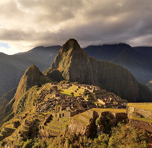
Imagine a town perched on the back of a mountain, so high that clouds sometimes float below it. On both sides the ground drops steeply down to a roaring river. That is Machu Picchu, in the Andes mountains of Peru in South America.
The Inca people built it in the 1400s. They had no iron tools, no wheels for carts and no horses. Still, they cut hard granite into blocks so neatly that the stones fit together without any cement, like a giant jigsaw puzzle. Some joints are so tight you cannot slide a thin card between them.
Machu Picchu was not a big city. It was more like a mountain palace with houses, temples, workshops, fountains and long staircases. Most scientists think it belonged to a great Inca king named Pachacuti. He and his family could stay there, and a few hundred workers lived there to look after it.
All around the town the Inca built giant steps on the mountainside, called terraces. The terraces made flat places to grow food and stopped the mountain from sliding away in the heavy rain. Hidden under the ground are clever drains that carry the water away.
After Spanish soldiers arrived in Peru in the 1530s, the people left Machu Picchu. The Spanish never wrote about it, so it was never destroyed. Local farmers always knew it was there, but the wider world only heard about it after an American explorer, Hiram Bingham, was guided up the mountain in 1911. Today it is one of the most famous places on Earth.
At a glance
- Built
- 15th century; radiocarbon dates from burials show occupation from about AD 1420 to 1532
- Place
- Ridge between the peaks of Machu Picchu and Huayna Picchu, above the Urubamba River, about 80 km northwest of Cusco, Peru
- Altitude
- About 2,430 m above sea level, where the high Andes meet the forested eastern slopes
- Builders
- The Inca state (Tawantinsuyu); traditionally linked to the ruler Pachacuti
- Function
- Most likely a royal estate with palaces, temples and a resident community of a few hundred retainers
- Original name
- Uncertain; recent archival research suggests it was called Picchu or Huayna Picchu
- Status
- Historic Sanctuary of Machu Picchu, UNESCO World Heritage (mixed cultural and natural site), 1983
- Wider fame
- Publicized worldwide after Hiram Bingham’s visit of 24 July 1911 and the National Geographic issue of April 1913
Easy
What is Machu Picchu?
Machu Picchu is the ruin of a fifteenth-century Inca settlement on a saddle-shaped ridge in the Andes of southern Peru. To the south rises the mountain called Machu Picchu (“old peak” in Quechua); to the north the sharp peak of Huayna Picchu (“young peak”). Far below, the Urubamba River (also called the Vilcanota) wraps around the ridge on three sides. The site lies at about 2,430 m, lower and warmer than the Inca capital Cusco, in the zone where the cold highlands give way to the humid forests that lead down to the Amazon.
The settlement covers only a few hectares, but it contains well over a hundred buildings: houses, halls, temples, storehouses and workshops, linked by some hundreds of stone stairways and framed by terraces that spill down the mountainside. A large central plaza divides it into two main parts. Water from a mountain spring runs through a stone channel into a chain of small fountains that step down through the town.
Machu Picchu is famous for three things at once: the beauty of its setting, the skill of Inca stonework and engineering, and the story of how it survived, unrecorded by Spanish colonial writers, until it became known to the outside world in the early twentieth century. UNESCO lists it as one of only a few dozen “mixed” World Heritage Sites, valued for both its cultural and its natural importance.
Easy
How to “read” Machu Picchu: a walk through the town
Visitors usually arrive near the southern end, where the agricultural sector lies: broad terraces of stone and earth and a few buildings for storage and for guards. A dry moat and a long wall separate this zone from the urban sector, which is entered through a single main gate with a massive stone lintel. The layout tells us that entry into the town was controlled.
The urban sector is divided by the central plaza. On the western, higher side are the most carefully built structures. The Sacred Plaza is bordered by the Main Temple and the Temple of the Three Windows, whose trapezoidal openings look east over the plaza. Above them, on a small hill, stands the Intihuatana, a stone carved from the living bedrock into angled planes and a short upright post. Its name, often translated “hitching post of the sun”, is a later label; the stone’s exact purpose is unknown, though it was clearly of great ritual importance.
Nearby is the building often called the Temple of the Sun, or Torreón: a tower with a curved wall of beautifully fitted stones built over a natural rock outcrop. One of its windows lines up with the sunrise at the June solstice, the Andean midwinter. Under it lies a cave with carved niches, sometimes called the Royal Tomb, though no burials were found there. Next to the Torreón is a finely built residence that many scholars identify as the ruler’s own quarters, with its own private garden, bath and direct access to the first fountain.
The eastern, lower side holds groups of houses and workshops, many built of rougher stone. At the southern edge is the Temple of the Condor, where a flat rock carved like a condor’s head and natural rocks resembling outstretched wings create the image of the sacred bird. Beyond the town, paths lead to Huayna Picchu, to a narrow Inca bridge on the cliff face and to the Sun Gate (Inti Punku), where the Inca road from Cusco first reveals the town.
Easy
How the Inca built it
Inca builders used the mountain itself as a quarry. Granite boulders scattered across the ridge were split with stone hammers and bronze tools, then shaped by pounding with harder hammerstones. Blocks were probably moved with ropes, levers and ramps by large teams of workers. The Inca had no draft animals strong enough to pull heavy loads; llamas carry only small packs.
Two kinds of masonry can be seen. The most important buildings use ashlar: carefully shaped blocks fitted together without mortar, sometimes in regular rows and sometimes as many-sided stones locked into one another. Ordinary buildings use rougher fieldstones set in mud mortar, which were originally plastered and may have been painted. Doors, windows and wall niches are trapezoidal, wider at the bottom than at the top, and walls lean slightly inward. These features help the buildings resist earthquakes, which are common in the Andes.
Perhaps the greatest engineering is invisible. The ridge receives heavy rain in the wet season, and the site sits between two geological faults. Inca builders created deep foundations and filled the terraces with layers of rock, gravel, sand and topsoil so that rain would soak in and drain away rather than wash the mountain down. Surface channels and drains run throughout the town. A study by the American hydrologist Kenneth Wright and the Peruvian archaeologist Alfredo Valencia Zegarra concluded that this drainage system is one reason the site has survived so well for five centuries.
Intermediate
The society that built it: the Inca Empire
In the early fifteenth century the Inca were one of several competing groups in the Cusco region. According to Spanish colonial chronicles based on Inca oral traditions, the turning point was a war against the neighbouring Chanka, in which a prince later known as Pachacuti (often translated “he who overturns the world”) saved Cusco and seized the throne. Pachacuti and his successors, especially his son Topa Inca Yupanqui, then conquered an empire, Tawantinsuyu (“the four parts together”), that eventually stretched some 4,000 km from what is now Ecuador and southern Colombia to central Chile. Historians disagree about how much of the Chanka story is history and how much is later royal legend.
The Inca state had no market money and no alphabetic writing. It recorded information with knotted cords called khipu and organized labour through mit’a, a system in which communities owed periods of work to the state in return for food, drink and hospitality during the work. A great network of roads, the Qhapaq Ñan, with way stations and storehouses, tied the empire together; Machu Picchu was connected to Cusco by one of its branches.
Pachacuti is also credited with rebuilding Cusco as a monumental capital. Inca rulers created country estates for themselves and their descendants, in the Urubamba valley and elsewhere, with palaces, fields and resident workers. These estates were the private property of the ruler’s lineage (panaqa), which continued to own and use them after his death. Places such as Pisac, Ollantaytambo and Machu Picchu belong to this pattern of royal estates in the valley north of Cusco.
Intermediate
Why was Machu Picchu built? Estate, sanctuary and landscape
For much of the twentieth century people speculated about Machu Picchu’s purpose: a fortress, the last refuge of the Inca, a convent for “Virgins of the Sun”. The key evidence for today’s interpretation came from colonial documents. In 1990 the American anthropologist John Rowe published sixteenth-century legal papers showing that lands at “Picchu” had belonged to Pachacuti and were still claimed by his descendants after the Spanish conquest. Most archaeologists now see Machu Picchu as a royal estate of Pachacuti and his lineage.
As an estate, the site served several purposes at once. It was a retreat where the ruler, his family and guests could rest, feast and hold ceremonies, probably mainly in the drier months. It was a religious centre where the sun, the mountains and water were honoured. And it was a statement of power: building a finely crafted town on such a difficult ridge showed the reach of the Inca state. The resident population is usually estimated at around 750 people, most of them retainers who maintained the buildings and served the elite.
Location mattered. In Andean religion, mountains (apu) are powerful beings, and springs, rocks and rivers can be sacred (huaca). Machu Picchu is surrounded by important peaks, including Salcantay to the south, and encircled by the Urubamba, which the Inca regarded as sacred. Many buildings frame particular peaks or incorporate natural rocks, and several structures are aligned with solstice sunrises or sunsets. Scholars debate how systematic these alignments are, but it is clear that the builders designed the town in dialogue with the landscape.
Intermediate
Who lived there? Evidence from burials and DNA
During his expeditions of 1912 and 1915, Bingham’s team excavated more than a hundred burials in caves and rock shelters around the site. Early analysis suggested that most of the skeletons were female, which fed the romantic idea of a community of “chosen women”. Later re-examination of the bones by physical anthropologists found a much more balanced mix of men and women, and the “Virgins of the Sun” theory has been abandoned.
The people buried at Machu Picchu were not the royal family, who would have been buried with great ceremony in Cusco, but the permanent staff. Colonial sources describe such retainers as yanacona, people removed from their home communities to serve the Inca elite for life. Studies of the skeletons show that many had eaten maize and led working lives, but most had not done extremely heavy labour.
In 2023 a team led by Lucy Salazar, with Richard Burger and geneticists including David Reich, published an ancient DNA study of 34 individuals buried at Machu Picchu. It found that the community came from many parts of the empire, including the coast, the highlands and the Amazon, and that people of different ancestries lived, had children and were buried together. This supports colonial descriptions of estate workers drawn from many ethnic groups. It also shows how Inca imperial policy moved people across great distances.
Intermediate
Abandonment and the Spanish conquest
Machu Picchu was occupied for only about a century. In the late 1520s epidemics of European diseases, possibly smallpox, spread through the Andes ahead of the Spanish themselves, killing the ruler Huayna Capac. His sons Huascar and Atahualpa then fought a destructive civil war. In 1532 a small Spanish force under Francisco Pizarro captured Atahualpa at Cajamarca; he was executed the next year, and the Spanish entered Cusco in 1533.
With the fall of the Inca state, the system of royal estates collapsed. The radiocarbon dates from Machu Picchu’s burials end around the time of the conquest, and the site seems to have been gradually abandoned in the following decades. From 1537 to 1572 an independent Inca state survived in the remote Vilcabamba region, northwest of Machu Picchu, until the Spanish captured and executed its last ruler, Túpac Amaru, in 1572. Machu Picchu lay close to this frontier, but there is no clear evidence that it played a role in Vilcabamba’s resistance.
Because no Spanish chronicler described Machu Picchu, the town escaped the systematic destruction of Inca shrines carried out by colonial authorities and missionaries. The buildings gradually lost their thatched roofs and were overgrown by forest, but their stone walls remained largely intact. The name of the place survived in local documents, and farmers continued to live and grow crops on some of the terraces.
Intermediate
“Lost city”? Bingham, local knowledge and the Yale collections
Machu Picchu was never truly lost. In 1902 the Cusco farmer and explorer Agustín Lizárraga reached the ruins and wrote “A. Lizárraga 1902” in charcoal on a wall of the Temple of the Three Windows. Nineteenth-century maps and local land records mention the place, and families were farming its terraces when outsiders arrived.
Hiram Bingham III, a lecturer at Yale University, came to Peru searching for Vilcabamba, the last Inca refuge. On 24 July 1911 the farmer Melchor Arteaga guided him up the mountain, accompanied by a Peruvian police sergeant; at the top, the families of Richarte and Álvarez were living and farming among the ruins, and a boy led him to the finest buildings. Bingham at first recognized Lizárraga’s earlier visit but later increasingly presented himself as the discoverer. He believed he had found Vilcabamba; in fact the ruins of Vilcabamba were later identified at Espíritu Pampa, far to the west, which Bingham had also visited.
Bingham returned with Yale and the National Geographic Society in 1912 and 1915. The April 1913 issue of National Geographic, devoted entirely to Machu Picchu, made it famous. His teams cleared the site, mapped it, and exported thousands of artefacts and human remains to Yale under permits that the Peruvian government regarded as a loan. The dispute over their return lasted nearly a century. After an agreement and a lawsuit brought by Peru, Yale returned the collections in 2011–2012; they are now held in Cusco in partnership with the National University of San Antonio Abad.
Many Peruvians and historians today emphasize that Bingham’s real achievement was publicity and scientific documentation, not discovery. The “lost city” story, repeated in countless books and films, erased the Peruvian and Indigenous people who had long known the site.
Intermediate
Heritage, tourism and conservation today
Peru declared the area a Historic Sanctuary in 1981, protecting both the ruins and the surrounding mountain forests, which are home to rich plant and animal life, including the spectacled bear and many species of orchids. UNESCO inscribed the Historic Sanctuary of Machu Picchu on the World Heritage List in 1983 for both its cultural and natural value. In 2014 the Qhapaq Ñan, the Inca road system, was inscribed as a separate World Heritage Site shared by six countries.
Machu Picchu is Peru’s best-known symbol and a major source of income. Most visitors travel by train to the town of Aguas Calientes (Machupicchu Pueblo) and then by bus up a road built in the mid-twentieth century; others hike the multi-day Inca Trail. Visitor numbers have grown to well over a million a year, and the Peruvian government sets daily limits, timed entry and fixed routes. These rules have changed several times and remain controversial, balancing protection of the site against the livelihoods of local people.
Conservation challenges include erosion and landslides, the wear of millions of footsteps, uncontrolled growth of the town below, and damage from accidents: in 2000, for example, a crane used while filming an advertisement chipped the Intihuatana stone. Indigenous Quechua communities of the region also seek a greater voice in how the site is managed and presented.
Advanced
Debates: dating Machu Picchu and the Inca chronology
For decades the date of Machu Picchu was derived from documents. The widely used chronology of Inca rulers proposed by John Rowe in the 1940s, based mainly on the chronicle of Miguel Cabello Valboa (1586), placed Pachacuti’s accession in 1438. Because Machu Picchu was thought to have been built for Pachacuti after he conquered the lower Urubamba, its construction was usually dated to around 1450 or later, and the site was assumed to have been occupied for only about 80 years.
In 2021 Richard Burger, Lucy Salazar, Jason Nesbitt, Eden Washburn and Lars Fehren-Schmitz published 26 accelerator mass spectrometry (AMS) radiocarbon dates from human bones and teeth excavated in Bingham’s time. The results indicate that Machu Picchu was continuously occupied from about AD 1420 to 1532, some two decades earlier than the conventional chronology allows. The authors argued that the colonial chronicles, compiled a century after the events, compress Inca history, and that Inca imperial expansion may have begun earlier than Rowe’s dates imply. Other scholars have used radiocarbon dates from other Inca sites to reach similar conclusions.
These findings do not settle every question. Radiocarbon dates from burials date the lives of the people, not the construction of particular buildings, and calibration curves for the fifteenth century have wide margins. The relationship between the new dates and the reigns of Pachacuti and Topa Inca remains debated, and some researchers still prefer to see construction as spread over two reigns. The broader lesson is methodological: Inca chronology built only on Spanish texts must be tested against independent archaeological dating.
Advanced
Debates: the site’s name, its function and the sources
What did the Inca call it? In 2021 the historian Donato Amado Gonzales and the archaeologist Brian Bauer, working with Bingham’s field notes, nineteenth-century maps and sixteenth- and seventeenth-century documents, argued that the town was originally called Picchu, or more likely Huayna Picchu, and that the name Machu Picchu became attached to the ruins only through Bingham’s publications. Among their evidence is a 1588 document stating that people of the Vilcabamba region were considering returning to “Huayna Picchu”. The argument has been widely reported, but the name Machu Picchu is now so established that no one proposes to change it.
What was it for? The royal-estate interpretation rests on the colonial documents published by Rowe, on the architecture (elite residences, fine temples, a small but diverse resident population) and on comparison with other estates in the Urubamba valley. Alternative or complementary views stress the site’s role as a religious sanctuary and pilgrimage destination, its astronomical alignments, or its position on the frontier with the Amazonian lowlands, which may have given it economic and strategic importance. These are not mutually exclusive, and many scholars now emphasize the combination of residence, ritual and display.
How reliable are the sources? Written evidence comes mainly from Spanish chronicles such as those of Juan de Betanzos (1551) and Pedro Sarmiento de Gamboa (1572), which record Inca oral histories but were shaped by the interests of their informants and of colonial officials, and from colonial legal documents about land. Archaeological evidence comes from the architecture, from the material excavated in 1912–1915 (much of it studied only after its return to Peru) and from later Peruvian excavations. Bioarchaeology, isotopes and ancient DNA have recently added direct evidence about the people who lived there.
Key ideas
- Royal estate
- A country property with palaces, fields and resident workers owned by an Inca ruler and his descendants; Machu Picchu is best understood as one.
- Ashlar masonry
- Precisely shaped stones fitted without mortar, used for the most important Inca buildings.
- Engineering with the landscape
- Terraces, foundations and drains turned an unstable, rainy ridge into a long-lasting town.
- Sacred landscape
- Mountains, rocks, springs and rivers were powerful beings in Andean religion, and the town was designed in relation to them.
- Mobile labour
- DNA shows that the residents came from across the empire, reflecting Inca policies of moving people to serve the state and the elite.
- The myth of the lost city
- The site was known locally before 1911; the discovery story reflects how outsiders framed it.
- Testing the chronicles
- Radiocarbon dating shows that written Inca chronologies must be checked against archaeology.
Records
- c. 1420 — Burials show that people are living at Machu Picchu, according to AMS radiocarbon dates.
- c. 1438 — Traditional date (from Rowe’s chronology) for Pachacuti’s accession after the war against the Chanka.
- 1532 — The Spanish capture Atahualpa at Cajamarca; the latest radiocarbon dates from Machu Picchu fall around this time.
- 1572 — The Spanish capture Vilcabamba and execute Túpac Amaru; by now Machu Picchu has probably been abandoned.
- 1588 — A colonial document mentions a place called “Huayna Picchu”, perhaps the original name of the town.
- 1902 — Agustín Lizárraga visits the ruins and leaves his name on the Temple of the Three Windows.
- 1911 — On 24 July, Melchor Arteaga guides Hiram Bingham to the site.
- 1913 — The April issue of National Geographic, devoted to Machu Picchu, makes it world-famous.
- 1981 — Peru declares the Historic Sanctuary of Machu Picchu.
- 1983 — UNESCO inscribes the Historic Sanctuary on the World Heritage List.
- 2011 — Yale begins returning artefacts excavated by Bingham’s expeditions to Peru (completed 2012).
- 2021 — New AMS radiocarbon dates push the start of occupation back to about 1420.
Glossary
- Inca
- Originally the title of the ruler, now used for the people and state of the Andean empire of the fifteenth and early sixteenth centuries.
- Tawantinsuyu
- The Quechua name of the Inca Empire, “the four parts together”.
- Quechua
- The language of the Inca state, still spoken by millions of people in the Andes.
- Terrace
- A flat step cut into a hillside and held up by a stone wall, used for farming and to stop erosion.
- Ashlar
- Masonry made of carefully cut and fitted stone blocks.
- Huaca
- A sacred place or object in Andean religion, such as a shrine, rock or spring.
- Apu
- A mountain spirit or sacred mountain in Andean belief.
- Mit’a
- The Inca system of rotating labour owed by communities to the state.
- Yanacona
- People removed from their home communities to serve the Inca elite permanently.
- Qhapaq Ñan
- The Inca road network, about 30,000 km or more, linking the empire.
- AMS radiocarbon dating
- A method of dating once-living material by measuring carbon-14 with an accelerator mass spectrometer, which needs only small samples.
Questions and answers
How did the Inca move such heavy stones up the mountain?
They mostly didn’t have to: the granite came from the ridge itself. Workers split and shaped boulders on the spot and moved blocks with ropes, levers and ramps.
Was Machu Picchu a lost city?
Not really. Local farmers lived on its terraces, and Agustín Lizárraga visited in 1902. It was “lost” only to outsiders until Hiram Bingham publicized it after 1911.
Why didn’t the Spanish destroy it?
No Spanish chronicler recorded it, probably because it had lost its importance and was abandoned after the conquest, so it escaped the destruction of Inca shrines.
How many people lived there?
Estimates suggest about 750 residents at most, mostly retainers, with more when the ruler and his court visited.
When was it built?
Traditionally around 1450 for Pachacuti, but radiocarbon dates published in 2021 show occupation from about 1420 to 1532.
What was the Intihuatana used for?
Nobody knows exactly. It is a carved bedrock outcrop of great ritual importance, possibly related to observing the sun or honouring the surrounding mountains.
Is “Machu Picchu” the original name?
Probably not. Research by Amado Gonzales and Bauer suggests the Inca called the town Picchu or Huayna Picchu.
Why were the Yale collections controversial?
Peru considered the objects and human remains excavated in 1912–1915 to be a loan; Yale kept them for nearly a century before returning them in 2011–2012.
Sources and further reading
- Historic Sanctuary of Machu Picchu. UNESCO World Heritage Centre
- Machu Picchu. Wikipedia
- Hiram Bingham III. Wikipedia
- Pachacuti. Wikipedia
- Inca road system. Wikipedia
- Richard L. Burger, Lucy C. Salazar, Jason Nesbitt, Eden Washburn, Lars Fehren-Schmitz, New AMS dates for Machu Picchu: results and implications. Antiquity 95 (383), 2021
- Lucy C. Salazar et al., Insights into the genetic histories and lifeways of Machu Picchu’s occupants. Science Advances, 2023
- Donato Amado Gonzales, Brian S. Bauer, The Ancient Inca Town Named Huayna Picchu. Ñawpa Pacha 42 (1), 2021
- Richard L. Burger, Lucy C. Salazar (eds.), Machu Picchu: Unveiling the Mystery of the Incas. Yale University Press, 2004
- Kenneth R. Wright, Alfredo Valencia Zegarra, Machu Picchu: A Civil Engineering Marvel. ASCE Press, 2000
Related
- TenochtitlanCapital of the Mexica, founded on an island in Lake Texcoco and conquered in 1521.
- Nazca LinesLarge ground drawings and lines made by ancient communities in the desert of southern Peru.
- Chichén ItzáA major Maya city on the Yucatán Peninsula, with monuments built and used across several centuries.
- TeotihuacanA major ancient city in central Mexico, known for its monumental avenues, pyramids and extensive residential compounds.
- Columbus's First VoyageChristopher Columbus's 1492 Atlantic voyage for the Spanish Crown reached islands inhabited by Indigenous peoples.
- Angkor WatMonumental temple complex built in the Khmer Empire under King Suryavarman II.
Written with AI assistance from the published sources listed above, and revised as new research appears.