Start at the top for an easy introduction. Go further down for more detail and scholarship.
- Easy
- Intermediate
- Advanced
For young readers
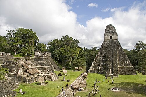
Deep in the rainforest of Guatemala, the tops of giant stone pyramids stick up above the trees. Monkeys howl and parrots fly past. This is Tikal, a city built by the Maya people, who still live in Central America today.
At its busiest, tens of thousands of people lived in and around Tikal. There were palaces for kings, big open plazas for ceremonies, ball courts for a sacred ball game, markets, houses and fields. The tallest temple is about 70 metres high, as tall as a 20-storey building.
The Maya had their own writing, made of picture-like signs called glyphs. They carved them on tall stones called stelae to tell who was king, when he was born, which wars he won and which gods he honoured. Because experts can now read most of these signs, we know the names of many of Tikal’s kings.
Tikal had a big rival city called Calakmul. For hundreds of years the two cities fought, made friends with other cities and tried to be the most powerful. Once Tikal lost badly, and for more than a hundred years its kings put up no new dated monuments and built far less, but then a new king won a great victory and the city grew bigger than ever.
About 1,100 years ago people slowly left the city, and the forest grew over it. The Maya people did not disappear, though. Their descendants still speak Maya languages and live in the region, and Tikal is now a national park protecting both the ruins and the wild animals of the forest.
At a glance
- What
- One of the largest cities of the Classic Maya, with temples, palaces, plazas, reservoirs and thousands of structures
- Place
- Petén Department, northern Guatemala, in the lowland tropical forest
- Ancient name
- Yax Mutal (“First Mutal”), shown by the city’s emblem glyph
- Occupied
- Farming villages from about 1000 BC; monumental building from about 400–300 BC; peak c. AD 200–900
- Key events
- Arrival of Siyaj K’ak’ linked to Teotihuacan (378); defeat and “hiatus” (562); victory over Calakmul (695); last dated monument (869)
- Tallest building
- Temple IV, about 70 m, one of the tallest structures of the ancient Americas
- Population
- Estimates range widely, from about 10,000 to as many as 90,000 people at the Late Classic peak
- Status
- National park (1955); UNESCO World Heritage Site (1979)
Easy
What is Tikal?
Tikal is the ruin of a great Maya city in the Petén region of northern Guatemala, a low, flat area covered by tropical forest. It was one of the most powerful cities of the Classic Maya period, roughly AD 250 to 900, when dozens of Maya kingdoms competed across what is now southern Mexico, Guatemala, Belize and Honduras.
The name “Tikal” is modern and is usually explained as a Yucatec Maya phrase meaning “at the waterhole”. In their own inscriptions, the city’s rulers called their kingdom Mutal or Yax Mutal. We know this from the “emblem glyph”, a special sign used in royal titles that identified each kingdom, a little like a coat of arms.
What visitors see today is the ceremonial heart of the city: steep temple-pyramids, palaces with many rooms, broad plazas, ball courts and rows of carved stone monuments. But Tikal was much more than a religious centre. Archaeologists have mapped thousands of houses, reservoirs, causeways and fields spreading far into the forest, showing that it was a true city.
Tikal is protected as a national park, created in 1955, and was inscribed as a UNESCO World Heritage Site in 1979, recognised both for its archaeology and for the rainforest that surrounds it.
Easy
How to “read” the city
At the centre lies the Great Plaza. On its east side stands Temple I, also called the Temple of the Great Jaguar, about 47 metres tall; facing it on the west is Temple II. Temple I was the funerary monument of one of Tikal’s greatest kings, Jasaw Chan K’awiil I, whose tomb lies deep beneath it. The temples face each other across the plaza, so ceremonies there took place between the monuments of a king and, it is often thought, his queen.
North of the plaza is the North Acropolis, a platform built up over many centuries where generations of kings were buried, each new building covering the older ones like layers of a cake. South of the plaza is the Central Acropolis, a maze of palace rooms and courtyards where the royal family and nobles lived and worked.
Further west rises Temple IV, the tallest building at Tikal, about 70 metres high. From its top you look out over an ocean of forest from which the roof-combs of other temples emerge. To the south-west is the Mundo Perdido (“Lost World”) complex, the largest ceremonial group of the Preclassic period at Tikal, showing that the city was already important long before its famous Classic temples.
Wide raised roads called causeways connected the main groups. Tikal is also known for its “twin-pyramid complexes”, pairs of flat-topped pyramids built to celebrate the end of a k’atun, a period of about twenty years in the Maya calendar. A carved stela and altar in each complex recorded the king who performed the ceremony.
Easy
Life in a rainforest city
Living in the Petén was not easy. There are no large rivers near Tikal, and for part of the year there is almost no rain. The people of Tikal solved this by building reservoirs: paved plazas and slopes channelled rainwater into large stone-lined tanks. Archaeologists have identified about ten major reservoirs that were essential for the city’s survival in the dry season.
Most people were farmers who grew maize, beans and squash, and also used the forest for fruit, game and wood. The recent laser surveys of the region show terraces, canals and raised fields, evidence that the Maya changed their landscape on a large scale to feed large populations.
The Maya had a writing system of several hundred signs, some standing for whole words and others for syllables. Scribes painted books on bark paper, and sculptors carved inscriptions on stelae, altars and lintels. They used a precise calendar, the Long Count, to date events to the day. Thanks to decades of decipherment, historians can now read the history of Tikal’s dynasty from the city’s own monuments.
Intermediate
From village to kingdom
The first farmers settled around Tikal by about 1000 BC. Large-scale building began around 400–300 BC, and the University of Pennsylvania’s excavations concluded that Tikal was “a going concern” by about 600 BC. In the Late Preclassic period the Mundo Perdido complex and the early North Acropolis were already monumental.
Later rulers traced their dynasty back to a founder named Yax Ehb Xook, who probably lived in the 1st or 2nd century AD. The dynasty kept careful count of its rulers, and later kings proudly gave their position in this line of succession. During the Early Classic period (about AD 250–550) Tikal grew into one of the leading cities of the lowlands, competing with neighbours such as Uaxactun, only about 20 km to the north.
The early kings built tombs in the North Acropolis and raised stelae showing themselves in rich costume, holding symbols of divine power. Maya kings claimed a special relationship with the gods and ancestors, and much of the city’s ritual life revolved around royal ceremonies, bloodletting offerings and the commemoration of calendar periods.
Intermediate
378: strangers from the west
In January 378 the inscriptions of Tikal and nearby cities record the “arrival” of a man called Siyaj K’ak’ (“Fire Is Born”), coming from the west. On the same day, Tikal’s king Chak Tok Ich’aak I died. Within a year a new king, Yax Nuun Ahiin I, was installed at Tikal, and inscriptions describe him as the son of a figure nicknamed “Spearthrower Owl”, whose name is written with symbols associated with the great city of Teotihuacan in central Mexico, more than 1,000 km away.
After this event, Teotihuacan styles appear at Tikal and other Maya cities: warriors with central Mexican weapons and headdresses, pottery shapes and the talud-tablero style of architecture. Siyaj K’ak’ appears as an overlord at several other sites, including Uaxactun, suggesting a wide reorganisation of power in the lowlands.
About seventy years later, Yax Nuun Ahiin’s son Siyaj Chan K’awiil II set up Stela 31, which shows him in Maya royal dress flanked by his father dressed as a Teotihuacan warrior. The long text on its back is one of the key historical sources for this period. The monument shows how Tikal’s rulers later presented their foreign connection as a source of prestige and legitimacy.
Intermediate
Superpowers at war: Tikal and Calakmul
The history of the Classic period is dominated by the rivalry between Tikal and the Kaanul (“Snake”) dynasty, which from the 7th century ruled from Calakmul in what is now southern Mexico. Neither city conquered the whole Maya world. Instead each built networks of allied and subordinate kingdoms, and their struggle has been compared to a contest between two superpowers.
In 562 Tikal suffered a devastating defeat. Its king Wak Chan K’awiil may have been captured and killed, but his precise fate is uncertain. Inscriptions at Caracol record the war, and many scholars now think the victor was the Kaanul king known as Sky Witness, with Caracol as his ally. There followed more than a century, called the “Tikal hiatus”, in which no dated monuments were raised at Tikal and building on a grand scale fell off sharply.
In the 7th century Calakmul’s king Yuknoom Ch’een II (reigned 636–686) built up a powerful alliance. Dos Pilas, founded by a prince of Tikal’s own dynasty, switched to Calakmul’s side and fought against Tikal, so that two branches of the same royal family became enemies.
The balance changed in 695, when Tikal’s king Jasaw Chan K’awiil I (reigned 682–734) defeated Calakmul’s ruler Yuknoom Yich’aak K’ak’. Tikal recovered its power, and Jasaw and his son Yik’in Chan K’awiil launched a great building programme. Temple I, Jasaw’s funerary temple, and Temple IV, generally linked to Yik’in Chan K’awiil and dated to the mid-8th century, belong to this revival.
Intermediate
Meanwhile in the world
Tikal had no contact with Eurasia, so its history has to be read on its own terms, from its inscriptions and archaeology: the upheaval of 378, when Siyaj K’ak’ arrived with ties to distant Teotihuacan, and the long rivalry with the Kaanul dynasty. Setting these dates beside other parts of the world is still useful for a different reason—it reminds us that the Maya developed writing, astronomy and monumental cities entirely independently, at the same time as the empires of Rome, Persia and China.
In 562, the year Tikal was defeated, Silla absorbed the last Gaya kingdom on the Korean peninsula, and in Constantinople the rebuilt dome of Hagia Sophia was dedicated. Around the same time the Byzantine emperor Justinian and the Persian king Khosrow I agreed a long peace treaty. Just as Tikal fell under the shadow of Calakmul, the Mediterranean and Near East were organised around two great powers, Byzantium and Persia.
Tikal’s long hiatus overlapped with the burial of a king at Sutton Hoo in England (c. 625), the rise of Islam after Muhammad’s move to Medina (622) and the founding of the Tang dynasty in China (618). When Jasaw Chan K’awiil defeated Calakmul in 695, Silla had recently unified most of the Korean peninsula after its wars with Tang, and the Tang capital Chang’an, with its vast Daming Palace, was one of the largest cities in the world.
Tikal’s last dated monument was carved in 869. In the same century the Tang dynasty was weakening and Charlemagne’s empire in Europe had already divided among his heirs. The great era of Maya lowland kings was ending, while in the northern Yucatán cities such as Chichen Itza were growing.
Intermediate
The end of the royal city
In the 8th century Tikal was at its largest, but across the southern Maya lowlands trouble was growing. The number of dated monuments fell sharply, from dozens each year around 750 to none by about 900. Tikal’s last dated monument was carved in 869, and by about 950 the city centre was largely abandoned. Small groups continued to live among the ruins for some time afterwards.
Historians once spoke of a sudden, mysterious “collapse”. Today many prefer words such as transformation or rupture, because Maya civilisation did not vanish. Northern cities such as Chichen Itza and later Mayapan flourished, and millions of Maya people still live in Mexico, Guatemala and Belize, speaking some thirty Maya languages.
Explanations for the end of the southern cities include prolonged drought, endless warfare between kingdoms, overpopulation and deforestation, changes in trade routes and the loss of faith in kings who could no longer guarantee rain and prosperity. At Tikal, studies of the reservoirs have found signs of pollution, including mercury from cinnabar used in red pigments and algae blooms, which may have made some water unsafe during dry periods.
Intermediate
Rediscovery, excavation and new technology
Local people and chicle gatherers knew of ruins in the forest, but Tikal entered official records in 1848, when an expedition led by the Guatemalan official Modesto Méndez and Ambrosio Tut reached the site. In the following decades explorers photographed the temples and removed some carved wooden lintels to European museums.
From 1956 to 1969 the University of Pennsylvania Museum ran one of the largest archaeological projects ever undertaken in the Americas at Tikal, directed in the field by William Coe. It mapped the central area of the city, excavated the North Acropolis and restored major temples, before handing responsibility to Guatemala. Guatemalan archaeologists then continued with their own projects, including the investigation of Mundo Perdido.
In 2018 a team using airborne laser scanning (LiDAR) published a survey of more than 2,100 square kilometres of the Petén in the journal Science. The lasers “saw” through the forest canopy and revealed tens of thousands of previously unmapped structures, along with causeways, fields and fortifications around Tikal. The results suggest the lowlands were far more densely populated and more intensively farmed than earlier researchers imagined.
Tikal also has a place in popular culture: the view from its temples appeared as a rebel base in the 1977 film Star Wars. Tourism brings income to Guatemala but also raises questions about conservation and about how Maya communities benefit from their heritage.
Advanced
Different perspectives
Conquest or alliance in 378? Reading the inscriptions, the epigrapher David Stuart and others have argued that the “arrival” of Siyaj K’ak’ was a military intervention that overthrew the old dynasty and installed a ruler linked to Teotihuacan. Others emphasise that Teotihuacan influence was already present before 378, that Maya elites adopted foreign symbols for their own prestige, and that the evidence could fit a political alliance, a marriage link or trade relations. Scientific studies of the skeletons of Tikal’s elite have been used on both sides of the debate. The question remains actively debated.
Who defeated Tikal in 562? Earlier readings of Caracol’s Altar 21, championed by the archaeologists working at Caracol, presented the war mainly as Caracol’s triumph. Later readings by epigraphers such as Simon Martin identify the Kaanul king Sky Witness as the main victor, with Caracol acting as his ally. The difference matters because it changes the picture from a local war to a contest between two regional superpowers.
Why did the southern cities decline? Climate scientists point to lake sediments and cave formations recording severe droughts in the 9th century, and a 2018 study estimated rainfall reductions of around 40–50 percent. Many archaeologists accept drought as a major factor but stress that it struck societies already weakened by warfare, social inequality and environmental stress, and that different cities declined at different times. More than 80 explanations have been proposed; most scholars now think several causes combined.
Whose history is it? Accounts that speak of a “lost city” found by outsiders in 1848 or of a “vanished” civilisation have been criticised for ignoring the Maya people who remained in the region and local knowledge of the ruins. Maya organisations in Guatemala increasingly claim a voice in how sites like Tikal are interpreted and used, including for ceremonies. Presenting Tikal as part of a living Maya heritage, rather than only as an archaeological monument, is now an important goal for many researchers.
Advanced
Evidence and method: reading a city in the forest
Tikal’s history rests on two kinds of evidence that must be combined carefully. Inscriptions give names, dates and events, but they were commissioned by kings and tell the story from the royal point of view: they record victories and captures, rarely defeats. Archaeology, by contrast, shows houses, food, burials and building phases, the lives of ordinary people as well as of rulers. The “hiatus” after 562, for example, is visible both in the absence of dated monuments and in the pause in large construction.
Decipherment has transformed the field since the 1970s and 1980s. Before then, many scholars believed Maya inscriptions dealt mainly with the calendar and astronomy. Once it became clear that the script recorded spoken Maya language and royal history, cities such as Tikal gained a political history with named kings, alliances and wars. Chronicles such as Simon Martin and Nikolai Grube’s survey of Maya dynasties bring together these readings, though interpretations of individual passages continue to change.
Estimating population is especially difficult. Figures for Tikal range from about 10,000 to about 90,000 people, depending on how the city’s edges are drawn, how many houses were occupied at the same time and how many people lived in each. LiDAR has greatly increased the number of known structures, but archaeologists still need excavation to date them. The LiDAR team estimated that the Late Classic lowlands may have held roughly 7 to 11 million people, a figure that other researchers continue to test.
Finally, dates for buildings often depend on associated inscriptions, pottery styles and radiocarbon dating. This is why sources give slightly different dates and heights for Temple I and other structures. Where the evidence is uncertain, a careful account should give ranges rather than exact numbers.
Key ideas
- Divine kingship
- Maya kings claimed a special bond with gods and ancestors, and temples, stelae and ceremonies expressed this sacred authority.
- Emblem glyph
- A royal title naming a kingdom; Tikal’s kings were “holy lords of Mutal”.
- City-state rivalry
- Classic Maya politics was a network of many kingdoms, some grouped around the rival powers of Tikal and Calakmul.
- Foreign connection
- Links with Teotihuacan, whatever their exact nature, gave Tikal’s rulers prestige and changed its art and politics after 378.
- Water management
- Without rivers, Tikal depended on reservoirs that collected rainwater from paved surfaces.
- Transformation, not disappearance
- The southern royal cities declined in the 9th–10th centuries, but Maya peoples and cultures continued to the present.
- Seeing through the forest
- LiDAR mapping revealed the true scale of Tikal’s settlement, roads and fields hidden under the canopy.
Records
- c. 1000 BCE — The first farming villages are established in the Tikal area (Middle Preclassic).
- c. 400 BCE — Large-scale construction begins; Mundo Perdido and the North Acropolis grow over the following centuries.
- 378 CE — Siyaj K’ak’ “arrives” on 14 January; King Chak Tok Ich’aak I dies the same day. Yax Nuun Ahiin I becomes king soon after.
- 445 CE — Siyaj Chan K’awiil II dedicates Stela 31, recounting the dynasty’s history and Teotihuacan links.
- 562 CE — Tikal suffers a major defeat; King Wak Chan K’awiil may have been captured and killed. The “hiatus” of more than a century begins.
- c. 648 CE — Dos Pilas, ruled by a branch of Tikal’s dynasty, comes under Calakmul’s influence and fights against Tikal.
- 695 CE — Jasaw Chan K’awiil I defeats Calakmul’s king Yuknoom Yich’aak K’ak’; Tikal’s revival begins.
- 734 CE — Death of Jasaw Chan K’awiil I; Temple I is raised over his tomb in the following years.
- 869 CE — The last dated monument at Tikal.
- c. 950 CE — The city centre is largely abandoned.
- 1848 — An expedition led by Modesto Méndez and Ambrosio Tut records the ruins.
- 1956 — The University of Pennsylvania Tikal Project begins (to 1969).
- 1979 — Tikal National Park is inscribed on the UNESCO World Heritage List.
- 2018 — A LiDAR survey of the Petén published in Science reveals the scale of settlement around Tikal.
Glossary
- Stela
- A tall carved stone slab, often showing a king and an inscription with dates and events.
- Glyph
- A sign in Maya writing; some stand for words, others for syllables.
- Long Count
- A Maya calendar that counted days from a fixed starting point, allowing exact dates.
- K’atun
- A Maya calendar period of 7,200 days, about 20 years.
- Acropolis
- Here, a large raised platform with temples or palaces built over many generations.
- Roof-comb
- A tall decorative stone crest on top of a Maya temple.
- Talud-tablero
- A central Mexican architectural style of sloping walls topped by vertical panels, linked with Teotihuacan.
- Causeway (sacbe)
- A raised, plastered road linking parts of a Maya city.
- LiDAR
- Laser scanning from an aircraft that measures the ground surface through vegetation.
- Classic period
- The era of Maya history from about AD 250 to 900, when kings recorded their deeds on monuments.
Questions and answers
Did the Maya disappear?
No. The great southern royal cities were abandoned, but millions of Maya people live in Central America today and speak Maya languages.
How tall are Tikal’s temples?
Temple IV is about 70 metres tall and Temple I about 47 metres. They were built on high platforms so they rise above the forest.
How do we know the names of Tikal’s kings?
They carved their names, titles and dates on stone monuments, and scholars can now read most Maya glyphs.
Did Teotihuacan conquer Tikal in 378?
The inscriptions record the arrival of Siyaj K’ak’ and a change of king, and many scholars see an intervention linked to Teotihuacan, but whether it was a conquest, an alliance or something in between is still debated.
Why did people leave Tikal?
Probably because of several problems together: drought, warfare, stress on land and water, and a loss of trust in rulers. Scientists are still studying how these factors combined.
How many people lived in Tikal?
Estimates range from about 10,000 to 90,000, depending on how the city is defined and how houses are counted.
What did LiDAR change about Tikal?
It showed that the city and its region contained far more houses, roads, fields and defences than anyone had mapped on foot.
Sources and further reading
- Tikal. Wikipedia
- Tikal (Expedition Magazine). Penn Museum, University of Pennsylvania
- Tikal. World History Encyclopedia
- Siyaj K'ak'. Wikipedia
- Calakmul. Wikipedia
- Classic Maya collapse. Wikipedia
- Lasers reveal a vast, sophisticated Maya civilization under the Guatemalan jungle. Brown University, 2018
- Simon Martin and Nikolai Grube, Chronicle of the Maya Kings and Queens. Thames & Hudson, 2000 (2nd ed. 2008)
Related
- TeotihuacanA major ancient city in central Mexico, known for its monumental avenues, pyramids and extensive residential compounds.
- Maya scriptLogosyllabic writing system of the Maya, combining word signs and syllable signs, used from about 300 BC until the Spanish conquest and largely deciphered in the second half of the twentieth century.
- Chichén ItzáA major Maya city on the Yucatán Peninsula, with monuments built and used across several centuries.
- Popol VuhK'iche' Maya narrative of origins, divine figures and ancestral history.
- Sutton HooAn early 7th-century royal cemetery in eastern England whose Mound 1 held a 27-metre ship burial filled with gold, garnet jewellery and Byzantine silver.
- Hagia SophiaA monumental church built for the Byzantine emperor Justinian I in Constantinople between 532 and 537 CE.
Written with AI assistance from the published sources listed above, and revised as new research appears.