Start at the top for an easy introduction. Go further down for more detail and scholarship.
- Easy
- Intermediate
- Advanced
For young readers
About a thousand years ago, long before there were cars, horses or iron tools in North America, thousands of people lived together in a busy city beside the Mississippi River. Today we call it Cahokia. It stood where the state of Illinois is now, across the river from the city of St. Louis.
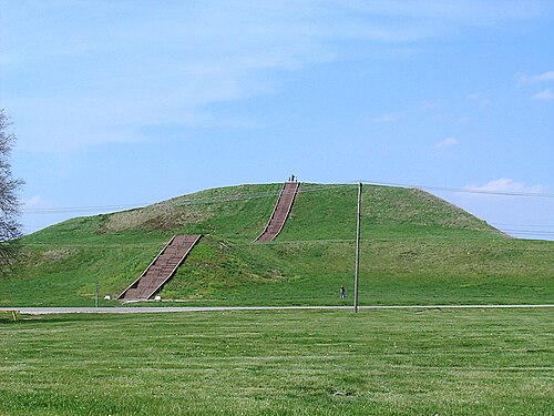
The people of Cahokia built huge hills out of earth. They did not have wheelbarrows or big animals to help them. Instead they dug the soil with tools of stone, wood and shell, filled baskets, and carried them on their backs, again and again, for many years. The biggest hill, called Monks Mound, is about as tall as a ten-storey building, and its base is bigger than a great pyramid of Egypt.
In front of Monks Mound there was an enormous flat square, as big as about thirty-five soccer fields. People gathered there for festivals and played a game called chunkey: one player rolled a stone disc, and players threw long sticks to guess where it would stop.
Cahokians were farmers. They grew corn, squash and other plants, and they also fished, hunted and gathered wild foods. Traders brought them shiny copper from the Great Lakes and seashells from the Gulf of Mexico, far to the south.
They watched the sky carefully. They set up giant circles of wooden posts, which archaeologists nickname “Woodhenge,” that may have helped them mark the days when the seasons changed.
After about three hundred years, people slowly moved away, and by around 1350 the city was almost empty. Nobody knows exactly why. But the people did not disappear: many Native American nations today, such as the Osage and the Ponca, remember Cahokia as part of their story, and they still visit it as a sacred place.
At a glance
- Period
- City flourished c. 1050–1350 CE; earlier villages from c. 600 CE; largely abandoned by c. 1350–1400
- Place
- American Bottom floodplain of the Mississippi River, near Collinsville, Illinois, USA, across from St. Louis, Missouri
- Culture
- Mississippian culture — the largest and most influential Mississippian centre
- Size
- The ancient city covered about 16 km² (6 sq mi); the protected state historic site covers about 890 ha (2,200 acres)
- Mounds
- Perhaps as many as 120 at the city’s height; about 80 survive, 72 of them inside the state site
- Population
- Estimates range from about 6,000 to 40,000 at the peak (c. 1100); many recent figures cluster between 10,000 and 20,000
- Largest structure
- Monks Mound, about 30 m (100 ft) high — the largest earthen mound north of Mexico
- Status
- U.S. National Historic Landmark (1964); UNESCO World Heritage Site (1982); managed by the Illinois Department of Natural Resources
Easy
What was Cahokia?
Cahokia was a Native American city built by people of the Mississippian culture on the broad, fertile floodplain of the Mississippi River known as the American Bottom. It lay near the meeting point of three great rivers — the Mississippi, the Missouri and the Illinois — in what is now southwestern Illinois. At its height, around 1100 CE, it was the largest settlement in North America north of Mexico.
The heart of the city was a great open plaza with a gigantic platform mound, Monks Mound, rising at its northern end. Around them stood more than a hundred other earthen mounds, rows of houses, open-air workshops, fields, borrow pits where earth had been dug, and, for part of the city’s history, a tall wooden wall. The urban area extended across the river to smaller mound groups at what are now East St. Louis and downtown St. Louis.
The name “Cahokia” is not what the builders called their city. It comes from the Cahokia, a group of the Illinois Confederation who lived in the area in the 17th and 18th centuries, long after the city had been emptied, and whose name French colonists attached to a nearby settlement. We do not know the city’s original name. Ponca oral tradition, however, remembers the ancestors’ time at a place called P'ahé'žíde, “red hill.”
Today the core of the site is preserved as Cahokia Mounds State Historic Site. In 1982 UNESCO added it to the World Heritage List, recognising it as the most important and largest centre of the Mississippian world.
Easy
How to “read” the city: mounds, plazas and posts
Cahokia’s mounds came in different shapes, and each shape seems to have had a job. Flat-topped platform mounds held important buildings — temples, council houses or the homes of leaders. Cone-shaped mounds and long ridge-topped mounds were often used for burials. Visitors who walk the site today can still see all three kinds.
The Grand Plaza, south of Monks Mound, covered about 20 hectares (50 acres). It looks naturally flat, but soil studies show that the ground was originally a series of low ridges and hollows. Early in the city’s history, the inhabitants deliberately levelled and filled it — one of their first large building projects. The plaza was a stage for ceremonies, feasts, markets and the game of chunkey.
The city was laid out with care. Around 1050 CE a grid oriented roughly to the cardinal directions was imposed on older villages. A raised causeway and a line of mounds ran south from the Grand Plaza to a large ridge-topped burial mound now called Rattlesnake Mound, creating a north–south axis through the city. Houses and smaller plazas were arranged in neighbourhoods around this core.
West of Monks Mound, archaeologists found the post holes of several great timber circles, nicknamed “woodhenges” after the famous monuments in England. They were built and rebuilt between about 900 and 1100 CE, each new circle larger than the last. A reconstructed circle with 48 posts around a central post now stands on the site, and it is used to study how Cahokians may have tracked the sunrise through the year.
Easy
Monks Mound: a mountain made by hand
Monks Mound is the largest human-made earthen mound north of Mexico. It is about 30 metres (100 feet) high, and its base measures roughly 290 metres long and between about 236 and 255 metres wide, depending on how it is measured — an area of 5–6 hectares, larger than the base of the Great Pyramid of Giza. It rises in several terraces, with a ramp on its south side facing the Grand Plaza.
All of this earth, hundreds of thousands of cubic metres of it, was dug and carried in baskets. Construction probably began in the 10th century and continued in as many as ten stages as the mound was raised and widened. Some recent studies suggest that much of the work could have been done in a few intense decades rather than over centuries. Builders also chose and layered different soils, clays and sands carefully, which helped the mound drain water and stay stable.
On the summit stood a very large building, over 30 metres long, which could be seen from all over the city. It may have been a temple, the home of a paramount leader, or both. Excavations in 1971 found the socket of a huge wooden post nearby, and an engraved sandstone tablet showing a “birdman” figure was found on the mound’s east side in the same year.
The name “Monks Mound” comes from French Trappist monks who lived on and near the mound from about 1809 to 1813 and grew vegetables on its terraces. It has nothing to do with the original builders.
Intermediate
Farming, crafts and trade
Cahokia rested on farming. Mississippian peoples grew maize (corn) on a large scale, alongside older native crops of the Eastern Agricultural Complex such as goosefoot, knotweed, little barley and sunflower, as well as squash. They also fished, hunted deer and waterfowl in the wetlands of the floodplain, and gathered nuts and wild plants. Recent research shows that Cahokians spread their fields between lowland and upland areas, so a single flood could not destroy the whole harvest.
Craft specialists made shell-tempered pottery, including the elegant Ramey Incised jars decorated with symbolic designs, as well as stone tools, marine-shell beads, and copper ornaments. Figurines carved from red flint clay, some showing women with baskets, hoes or plants, suggest a religion concerned with fertility, earth and renewal.
Goods moved along the rivers over great distances. Copper came from the Great Lakes region, lightning whelk shells and shark teeth from the Gulf Coast, and prized Mill Creek chert from southern Illinois. Cahokian styles of pottery, architecture and imagery in turn spread to distant communities, from Wisconsin to the lower Mississippi Valley.
People lived in rectangular houses with walls of wooden posts set in trenches, covered with thatched roofs. Around 1050 many households changed from older post-house styles to this new form at about the same time, a sign of how quickly the city reorganised everyday life.
Intermediate
The rise of the city: from villages to a “Big Bang”
People had lived in the American Bottom for thousands of years. By the Late Woodland period, around 600 CE, farming villages occupied the Cahokia area, and during the so-called Lohmann phase (roughly 900–1050 CE) these villages grew larger and more concentrated. Mound building here began with the emergence of Mississippian culture in the 9th and 10th centuries.
Then, in the years around 1050 CE, something dramatic happened. Within a generation or two, the settlement was rebuilt on a new plan, with the Grand Plaza, the causeway and dozens of mounds, and the population of the central area rose from perhaps 1,400–2,800 to perhaps 10,000–15,000 people. Archaeologists, notably Timothy Pauketat, have called this sudden transformation Cahokia’s “Big Bang.”
Much of this growth came from immigration. Pottery in styles from the lower Ohio valley, the lower Mississippi valley, the Upper Midwest and the Caddo region of the south-central plains appears in larger quantities at this time, and chemical studies of teeth show that many people buried at Cahokia had grown up elsewhere. The city seems to have drawn newcomers with the promise of a powerful religious and political centre.
The peak came in the Stirling phase (about 1100–1200 CE). If the highest population estimates are correct, no city in what later became the United States was larger until Philadelphia passed 40,000 people in the 1780s. Even with more cautious estimates, Cahokia was a genuine city, comparable in scale to many European towns of its time.
Intermediate
Religion, power and the sky
Cahokia was not only a place to live; it was a sacred landscape. Its layout tied earth, water and sky together. Mounds were aligned to the cardinal directions and, in some places, to the movements of the sun and moon. At the upland Emerald site east of the city, mounds were aligned to the 18.6-year cycle of the moon, and archaeologists think it was a shrine associated with the moon, water, femininity and fertility.
Much of Mississippian religious art shows a falcon-like “birdman,” a figure combining human and bird features that seems linked to warfare, the sky world and the renewal of life. Scholars often connect these images with later Siouan stories of heroes such as Morning Star or Red Horn, though such links across many centuries must be made with care.
Leadership at Cahokia was probably held by powerful families whose authority rested on religion as well as on control of labour and goods. Scholars debate whether this was a “chiefdom,” an early state, or something that does not fit either label. The size of the mounds shows that leaders could organise many thousands of workers, but whether people worked out of devotion, obligation, pride or coercion — or all of these — is hard to know.
The game of chunkey, which may have been invented or spread from Cahokia, also had a social and religious role. Large public games drew crowds, and chunkey players appear in Mississippian art. Sport, feasting and ritual together helped bind a diverse population into one community.
Intermediate
Mound 72: burials, sacrifice and a changing interpretation
Mound 72 is a small ridge-topped mound south of Monks Mound, excavated by the archaeologist Melvin Fowler and his team between 1967 and 1972, with further work in the 1990s. It turned out to hold the remains of about 270 people, buried in several episodes over roughly a century. Radiocarbon dates from wood in the mound fall around 950–1050 CE.
The most famous grave is the so-called Beaded Burial. Two elite individuals were laid out, one above the other, with a bed of about 10,000 marine-shell disc beads between them arranged in the shape of a bird. Nearby were caches of finely made arrowheads in styles from several different regions, rolled copper, mica and chunkey stones — evidence of Cahokia’s wide connections.
Mound 72 also contains grim evidence of human sacrifice. Scholars estimate that more than half of the people buried there were sacrificed. They include a group of four men without heads or hands, and mass graves of dozens of young women, arranged in layers. In one pit, some of the victims appear to have been buried while still alive. Some chemical and skeletal studies suggest that many of the young women came from outside the city and had poorer diets than the elite, raising hard questions about power and inequality.
For decades the Beaded Burial was described as the grave of a male ruler, often called the “Birdman.” A 2016 re-examination of the bones led by Thomas Emerson reported that the central burials included women as well as men, recasting the grave as a set of paired male and female burials. This has encouraged scholars to read Mound 72 as a staged cosmological drama about fertility, renewal and the order of the world, rather than simply a monument to one warrior king.
Intermediate
Walls, decline and departure
Around 1175 CE Cahokians built a wooden palisade about 3 kilometres (2 miles) long around the central precinct, with regularly spaced bastions. It was rebuilt several times, each time enclosing a smaller area. The wall may have served partly to separate sacred and elite space from the rest of the city, but bastioned walls almost always suggest a fear of attack, and burned villages from the 13th century in the Illinois River valley point to rising conflict in the region.
From about 1200 the population began to fall, and by around 1350 the city had been largely abandoned. People left not only Cahokia but a wide region of the central Mississippi and lower Ohio valleys, which archaeologists call the “Vacant Quarter.” Recent research, however, shows that the wider area was never completely empty and that population in the region rebounded after 1400.
Many explanations have been suggested: floods, drought, deforestation, soil exhaustion, overhunting, disease, food shortages, warfare, and political or religious conflict. Sediments from nearby Horseshoe Lake record major floods in about 1100–1260 and 1340–1460, but newer studies argue that Cahokians protected their core with channels and levees and found no evidence that they caused erosion by cutting forests. Some researchers point to changes in diet, such as a possible end to nixtamalisation (treating maize with lime) around 1200, which could have caused malnutrition.
Others stress social causes. Thomas Emerson and Kristin Hedman have argued that Cahokia’s large immigrant population, with different languages and traditions, made it hard to maintain a single shared identity. Most scholars now think that environmental stress and social tension combined, and that people chose to leave for smaller, more independent communities rather than suffering a sudden collapse.
Intermediate
Descendants and living connections
Cahokia is sometimes described as a “lost” civilisation, but its people did not vanish. Many scholars think that ancestors of the Dhegiha Siouan-speaking peoples — the Osage, Omaha, Ponca, Quapaw and Kaw — were among the people of Cahokia, and Ponca oral tradition speaks of their ancestors’ time there. Other nations of the Southeast, such as the Cherokee, Choctaw, Chickasaw and Muscogee (Creek), carry on mound-building and ceremonial traditions related to the Mississippian world.
The Osage Nation is today a primary partner of archaeologists and site managers. It has also bought Sugarloaf Mound in St. Louis, one of the last surviving Mississippian mounds on the Missouri side of the river, to protect it. Native people continue to come to Cahokia to hold ceremonies and dances.
These relationships are also changing how the site presents its past. Under updated rules of the U.S. Native American Graves Protection and Repatriation Act (NAGPRA), the site closed part of its museum galleries so that sacred and cultural objects would be displayed only with the consent of lineal descendants or affiliated tribes. For many Native communities, human remains and sacred objects from places like Mound 72 are ancestors and relatives, not just scientific specimens.
Listening to oral traditions alongside archaeology does not mean the two always agree, but together they give a fuller picture: Cahokia as the achievement of Indigenous people whose descendants are still here.
Intermediate
Destruction, rediscovery and protection
When Europeans and Americans settled the region, many did not believe that Native Americans could have built such monuments. Some imagined a vanished race of “Mound Builders” — a myth that helped justify taking Native land. Archaeology in the late 19th and 20th centuries disproved this idea and showed that the mounds were built by ancestors of Native peoples.
Meanwhile, many mounds were destroyed. St. Louis was once nicknamed “Mound City,” but nearly all the mounds in its downtown were levelled and used as fill in the mid-19th century. At Cahokia itself, farming, roads, housing and later interstate highways cut through the ancient city. In the 1950s federal highway building threatened the site, but salvage excavations along the new roads also produced some of the most important discoveries, including the woodhenges.
The State of Illinois began protecting the site in the 1920s, when the legislature authorised the purchase of land for a state park. It became a National Historic Landmark in 1964 and a UNESCO World Heritage Site in 1982. An interpretive centre opened in 1989 and now receives many visitors each year. The protected area covers about 890 hectares with 72 of the roughly 80 surviving mounds.
Conservation remains difficult. Monks Mound has suffered slumping — large sections of its western side have slid, a problem that began already around 1200 CE — and engineers carried out major stabilisation work into the 2000s. Development, drainage and erosion continue to threaten mounds outside the protected area.
Advanced
Scholarly debates: how big, how powerful, how urban?
The most persistent debate concerns population. Published estimates for the peak range from about 6,000 to over 40,000, and even the same data can yield different figures depending on assumptions about how many people lived in each house, how many houses were occupied at once, and how far the “city” extended. Salvage and research excavations since the 1990s, which found new residential zones to the west and in the uplands, pushed some estimates upward; site interpretation today often cites about 20,000 at the peak.
A related debate asks what kind of society Cahokia was. Some archaeologists, sometimes labelled “minimalists,” have seen it as a large but essentially decentralised chiefdom, similar in kind to other Mississippian centres. Others, including Timothy Pauketat, argue that the sudden planned rebuilding around 1050, the scale of labour, the evidence for sacrifice and Cahokia’s influence over a wide region point to a more centralised, state-like political and religious order — or to a new kind of Indigenous urbanism that should not be forced into models taken from Mesopotamia or Mesoamerica.
A third debate concerns the causes of decline. Earlier models of ecological overshoot — deforestation leading to floods and failing fields — have been challenged by sediment studies that find little evidence of human-caused erosion. Researchers now weigh climate change (including drought during the 13th century), flooding, diet, violence and social fragmentation, and increasingly frame the end of Cahokia as a process of deliberate emigration and reorganisation rather than a “collapse.”
Finally, scholars debate how to connect archaeological evidence with the beliefs and identities of living nations. Iconography such as the birdman and figurines of women with plants invite comparisons with Siouan and Southeastern oral traditions, but centuries of change separate them. Collaborative research with descendant communities is increasingly seen not only as an ethical obligation but as a source of insight.
Advanced
Evidence and methods
Because the Mississippians left no written records, knowledge of Cahokia rests on archaeology, earth science and oral tradition. Excavations since the early 20th century — including salvage work along interstate highways in the 1950s and 1960s — have mapped houses, post holes, pits and mounds. Radiocarbon dating and the typology of ceramics allow archaeologists to divide the site’s history into phases such as Lohmann, Stirling, Moorehead and Sand Prairie.
Soil coring and micromorphology have revealed how mounds were built: builders selected contrasting soils, placed them in deliberate layers, and sometimes capped surfaces with coloured clays. The discovery that the Grand Plaza was artificially levelled came from such studies. Botanical remains help date construction and show which crops people grew.
Bioarchaeology — the study of human remains — has provided information on diet, health, violence and migration, for example through strontium isotope analysis of tooth enamel. These methods raise ethical questions, and today such research is shaped by NAGPRA and by consultation with tribal nations. The 2016 reanalysis of Mound 72 shows how new methods and questions can overturn long-standing interpretations.
Environmental records from lake sediments supply climate and flood histories, and methods such as the analysis of fecal biomarkers in lake cores have been used to estimate population change over time. Combining these very different kinds of evidence — each with its own uncertainties — is the central methodological challenge of Cahokia studies.
Key ideas
- Indigenous urbanism
- Cahokia shows that Native North Americans built a planned, densely populated city with public spaces, neighbourhoods and monumental architecture, without writing, metal tools, wheels or draft animals.
- Earth as a building material
- Mounds were not simple piles of dirt: builders chose and layered soils with engineering knowledge, making enduring monuments by hand.
- Sacred landscape
- The layout of mounds, plazas, causeways and posts tied the city to directions, water, the sun and the moon, making the city itself a religious statement.
- Immigration and diversity
- Cahokia’s rapid growth around 1050 drew people from across the Midwest and South, a source both of vitality and, possibly, of later tension.
- Power and sacrifice
- Mound 72 reveals that Cahokian religion and leadership involved human sacrifice, reminding us that monumental achievements often had costs.
- Decline as migration
- Rather than a sudden collapse, the end of Cahokia is increasingly seen as a gradual process in which people chose to leave for new ways of life.
- Living heritage
- Descendant nations such as the Osage and Ponca maintain connections to Cahokia, and their perspectives increasingly shape research and display.
Records
- c. 600 CE — Late Woodland farming villages occupy the Cahokia area.
- c. 900 CE — Lohmann phase begins: villages grow and concentrate; Mississippian mound building starts; first timber circles.
- c. 1030 — Beaded Burial and early sacrificial burials in Mound 72.
- c. 1050 — Cahokia’s “Big Bang”: the city is rebuilt on a planned grid with the Grand Plaza; rapid population growth through immigration.
- c. 1100 — Stirling phase: Cahokia reaches its peak population; Monks Mound nears its final form.
- c. 1175 — First palisade built around the central precinct.
- c. 1200 — Moorehead phase: population begins to decline; slumping on Monks Mound.
- c. 1350 — The city is largely abandoned; the wider “Vacant Quarter” is depopulated.
- c. 1650 — Groups of the Illinois Confederation, including the Cahokia, move into the region.
- 1809 — French Trappist monks settle at the site (until 1813), giving Monks Mound its name.
- 1964 — Cahokia Mounds is designated a U.S. National Historic Landmark.
- 1982 — UNESCO inscribes Cahokia Mounds State Historic Site on the World Heritage List.
Glossary
- Mississippian culture
- A group of related Native American societies in the central and southeastern United States (c. 800/1000–1600 CE) known for maize farming, platform mounds, shell-tempered pottery and chiefdoms.
- Platform mound
- A flat-topped earthen mound built as a base for important buildings such as temples or leaders’ houses.
- American Bottom
- The broad floodplain of the Mississippi River in Illinois opposite St. Louis, where Cahokia was built.
- Chunkey
- A Native American game in which a stone disc was rolled and players threw poles to where they thought it would stop.
- Woodhenge
- The modern nickname for large circles of wooden posts at Cahokia, which may have marked solar events.
- Palisade
- A wall of tall wooden posts; Cahokia’s had bastions and enclosed the central precinct.
- Vacant Quarter
- Archaeologists’ term for the region of the central Mississippi and lower Ohio valleys that lost most of its population after c. 1350.
- Nixtamalisation
- Soaking and cooking maize in an alkaline solution such as lime, which makes its nutrients easier to absorb.
- Dhegiha Siouan
- A group of related languages and peoples — Osage, Omaha, Ponca, Quapaw and Kaw — many of whom trace ancestral links to Cahokia.
- NAGPRA
- The U.S. Native American Graves Protection and Repatriation Act (1990), which governs the treatment and return of Native remains and sacred objects.
Questions and answers
Was Cahokia really bigger than London?
Possibly. The site’s own interpretation says Cahokia was larger than London was around 1250 CE. Because population estimates range from about 6,000 to 40,000, the comparison depends on which figure you use, but even moderate estimates make Cahokia a large city for its time.
How did people build such big mounds without machines?
They dug soil with hoes and tools of stone, wood and shell and carried it in baskets. With many workers over years or decades, basket after basket added up to millions of cubic metres of earth.
Who lives there now? Did the people disappear?
The city was abandoned, but its people moved elsewhere. Several Native nations, especially Dhegiha Siouan peoples such as the Osage and Ponca, trace ties to Cahokia, and Native people still hold ceremonies at the site.
Why is it called Cahokia?
The name comes from the Cahokia people, part of the Illinois Confederation, who lived in the region centuries after the city was abandoned. The builders’ own name for the city is unknown.
What happened in Mound 72?
It held the burials of about 270 people, including an elite burial on a bed of shell beads in the shape of a bird and many people who appear to have been sacrificed. A 2016 study showed that the central burials included both men and women.
Was Cahokia a state?
Scholars disagree. Some see it as a large chiefdom; others argue that its planning, scale and regional influence show a more centralised, state-like society or a distinct Indigenous form of city.
Why did people leave?
No single cause is agreed. Suggested factors include floods, drought, diet, warfare and social tensions among a diverse population; many scholars think several of these worked together.
Sources and further reading
- Cahokia. Wikipedia
- Monks Mound. Wikipedia
- Mound 72. Wikipedia
- Mississippian culture. Wikipedia
- Cahokia Mounds State Historic Site. Cahokia Mounds Museum Society
- About. Cahokia Mounds Museum Society
- Timothy R. Pauketat, Cahokia: Ancient America’s Great City on the Mississippi. Viking, 2009
- Biloine Whiting Young and Melvin L. Fowler, Cahokia: The Great Native American Metropolis. University of Illinois Press, 2000
Related
- Pueblo BonitoThe largest great house of Chaco Canyon: a D-shaped, multi-storey masonry building of some 650–800 rooms and dozens of kivas, built c. AD 850–1150 by ancestors of today’s Pueblo peoples.
- TeotihuacanA major ancient city in central Mexico, known for its monumental avenues, pyramids and extensive residential compounds.
- Chichén ItzáA major Maya city on the Yucatán Peninsula, with monuments built and used across several centuries.
- Great ZimbabweRemains of a major southern African city built and occupied by ancestors of the Shona people.
- StonehengeA prehistoric monument of earthworks and standing stones in southern Britain, built and altered over many centuries.
Written with AI assistance from the published sources listed above, and revised as new research appears.